Data For Wind
Introduction

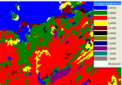
The DataForWind roughness dataset is giving you the roughness information for your wind farm based on information from the Corine Land Cover 2000 database (CLC2000). The data was transformed from the CLC2000 legend into an aerodynamic roughness length by DataForWind.
Coverage

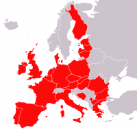
The DataForWind roughness data is a European 200 x 200 m roughness contour dataset with coverage between 31°N - 72°N and 11°W - 32°E. Please note, that most European countries are covered with the exception of Norway and Sweden, see the figure to the right. In addition, a few areas in Northern Africa are also included in the dataset.
Experience with the dataset

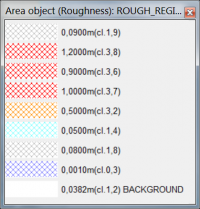
A sample of the classes in DataForWind dataset legend is shown in the figure to the right. As you can see, the legend displays the roughness length (m) as well as the roughness class. Be aware of the class 1.8-1.9. This is “open land” for the summer data set. These two layers are typically merged and given the “annual average open land roughness”, which can be anything from class 1 to class 3, depending on how the open land are distributed in the region under consideration. In some regions in Denmark as example, there are many wind breaks, making the roughness closer to class 3, while in other regions the open land are large open fields just with grass, and therefore closer to class 1.
Known Issues
When using the DataForWind data in the eastern part of Europe, we have found that data may be misaligned when comparing to maps and other data sources. You may need to adjust the positioning of the data by some hundred meters. This may be done directly by invoking the ‘EMD Editor’ connected to an Area Object. Use the “Transform” option, which enables you to directly use an arrow to “push” the data to the right map location.
External Links
- Data for Wind web site at: http://www.dataforwind.com
- Data for Wind roughness extraction tool at: http://www.dataforwind.com/extraction_clc.php
Acknowledgement
Source of this data set is DataForWind, www.dataforwind.com. Note, that you may also download the data directly from the http://www.dataforwind.com web site: In order to get the data into WindPRO, then - in this case - you will have to use the importer facilities in the WindPRO area object.