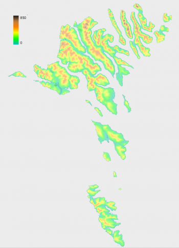
Faroe Islands Elevation Models

Introduction
The Environment Agency in the Faroe Islands has released several maps and geospatial datasets via its portals "føroyakort" (https://www.foroyakort.fo) and "kortal" (https://www.kortal.fo). The data are provided 'as-is' and via a national, open data license. Elevation data are available in three different DSM models in resolutions of 2m, 5m and 10m. As the Faroe Islands coordinate systems currently are not available in windPRO (summer 2023), then - for integration in windPRO - the finest resolution model (2m) has been resampled into geographical coordinates (EPSG:4326) using a bi-linear resampling algorithm. The models available in windPRO are 2m (0.06 arc-seconds), 5m (0.32 arc-seconds) and 10m (0.65 arc-seconds). The model is created from satellite imagery originating from 2017 - with the current version released in may 2019.
Dataset Overview
- Spatial Coverage: Faroe Islands (Kingdom of Denmark)
- Resolutions: 2m, 5m and 10m
- Data-type: Digital Surface Model (DSM)
- Coordinate system (in original data):
- Horizontal: ETRS89 / Faroe TM (EPSG:5316)
- Vertical: Unknown
- Version: Data downloaded in June 2023.
- Vertical Accuracy: Unknown (data is derived from satellite imagery).
Availability from within WindPRO
The data are available directly from within windPRO in 10-meter resolution. The data can be accessed from the online-services in the following objects:
- Line Object (with purpose to height contour lines)
- Elevation Grid Object
License and Attribution
The product belongs to the open data of the Environment Agency in the Faroe Islands. The data is released by a national, open data license. The copyright holder requires an attribution when displaying or using this data, according to the following scheme: The Faroese Environment Agency, Umhvørvisstovan, enforces its copyright. When using the data, the user must:
- at a location appropriate for the distribution medium, state the following:
- "Data from the Faroese Environment Agency, Umhvørvisstovan"
- The names of the dataset, i.e. "DSM hæddarmodell"
- When the datasets were downloaded, and/or whether webservices are used
- ensure that "The Faroese Environment Agency, Umhvørvisstovan" appears on the front page of the service, if other sources are also mentioned on the front page
- provide an available copy of these terms for third parties, perhaps in the form of a link to the license page
EMD recommends the following attribution when using this dataset:
Source: Contains elevation data from the Faroese Environment Agency, Umhvørvisstovan - DSM hæddarmodell - 06/2023.
Distribution: Through EMD and windPRO.
Data-license: https://www.foroyakort.fo/um-foroyakort/terms-and-conditions-in-english/
Acknowledgement
- The Faroese Environment Agency, Umhvørvisstovan are thanked for releasing this digital elevation dataset – and disseminating it in the public domain and thus for aiding the development of renewable energy.
External Links
- Description of the elevation model: https://www.foroyakort.fo/tak-datur-nidur/dsm-haeddarmodell/ (in Faroese)
- License conditions: in English or in Faroese