Finnish LUKE Forest Map
Introduction


The Natural Resources Institute Finland / Luonnonvarakeskus (Luke) is maintaining a forest map with Finnish National coverage. The map is developed using a multi-source approach – driven by ‘k-NN and ik-NN’ methods and aerial data obtained from a combination of LANDSAT and ALOS satellite images. The recent map holds a spatial coverage of the whole of Finland – with a grid resolution of 16m. In WindPRO, we only distribute the forest height data, but the full dataset also holds information about forest age, species and standing volume.
Currently (2023), forest maps are available for years 2021, 2019, 2017, 2015, 2013, 2011, 2009 and 2006. In windPRO we distribute the versions from 2021, 2019 and 2015. Please note: As the forest data is generate by machine learning algorithms and active forestry is also taking place, we recommend that you validate the forest patches by aerial imagery and/or a site inspection.
Usage Notes
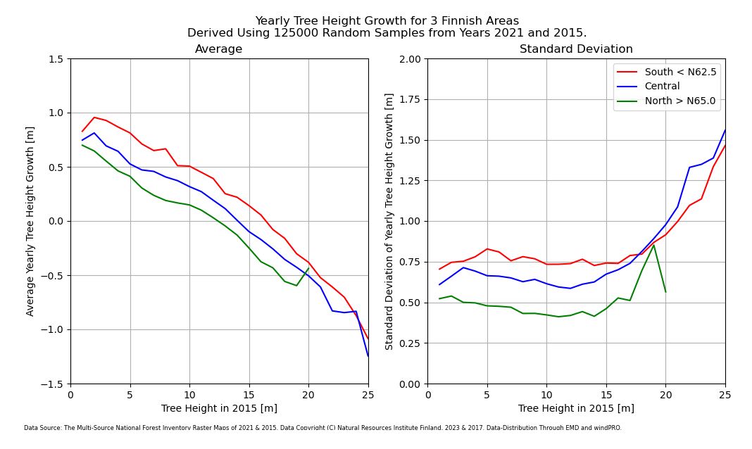
- How much are the tree heights actually changing (growing) over the years?
At the release time of the 2021 data (2023-10), EMD did an evaluation of the annual tree growth. This analysis is based on sampling data from 125.000 random locations around Finland and in 3 different regions: North (>N65.0), south (<N62.5) and central (N62.5 to N65.0). Only locations with land-cover classified as forest are used. The result is shown in the figure to the right. As seen, average tree growth is possitive for tree heights up to around 15m, then negative (on average) for taller trees due to felling and active forestry. A larger version of the figure is - here.
Data Applicability and Availability within windPRO
The LUKE forest height data are used as input for the dedicated sub-models in windPRO which takes takes into account the forest impact on the wind flow. This is the displacement height calculator and the Objective Roughness Approach (ORA) tool. Both forest models are available from windPRO 3.2+. The forest heighs in windPRO are delivered in meters.
The LUKE forest data is accessed from the online-services from the ‘elevation grid object’ with data-type set to ‘Heights above terrain (a.g.l) for elements’.
Technical Details (original data)
Dataformat:
- GeoTiff
Coordinate System:
- ETRS-TM35FIN (EPSG: 3067)
Pixel values:
- Stand mean height from years 2021, 2019 and 2015 (dm)
- 32766 is a missing value: the pixel belongs to forestry land but without satellite image cover
- 32767 is a null value: the pixel does not belong to forestry land or is outside of the country
Spatial Resolution:
- 16m
For the data in windPRO, the null values and missing data are neglected and heights in deci-meters have been converted to meters.
Acknowledgement
- The Natural Resources Institute Finland / Luonnonvarakeskus (Luke) is acknowledged for development and release of the free and open dataset of Finnish forest data – and thus for aiding the development of wind energy in forested areas.
- Integration of this dataset into EMD services was co-supported through the InnoWind project (www.innowind.dk) which is co-funded by the Danish Innovation Fund
Data Licenses
- 2021 and 2019-data: This work is licensed under the Creative Commons Attribution 4.0 International License (CC-BY-40).
- 2015-data: The map is released under an open-data license by the National Forest Institute of Finland (LUKE). Link to the licence conditions - CLICK HERE.
Attribution
If data from the LUKE Forest Map is used within a published product the following notification should be given:
For 2021 data: Source:
The Multi-source National Forest Inventory Raster Maps of 2021 - Copyright (C) Natural Resources Institute Finland, 2023. Distribution through EMD and windPRO.

For 2019 data: Source:
The Multi-source National Forest Inventory Raster Maps of 2019 - Copyright (C) Natural Resources Institute Finland, 2021. Distribution through EMD and windPRO.

For 2015 data: Source:
Forest height data - Copyright (C) - Natural Resources Institute Finland, 2017. Distribution through EMD and windPRO.
External Links
- Mäkisara, Kai; Katila, Matti; Peräsaari, Jouni; Tomppo, Erkki: The Multi-Source National Forest Inventory of Finland – methods and results 2013, (2016): Available at http://urn.fi/URN:ISBN:978-952-326-186-0
- More information about the Finnish multi-source national forest inventory is given at the LUKE web site CLICK HERE.