Iceland Elevation Model: Difference between revisions
m (→License) |
|||
| (11 intermediate revisions by the same user not shown) | |||
| Line 1: | Line 1: | ||
[[Category: Online Data]][[Category: Digital Elevation Models]][[Category: InnoWind]] | [[Category: Online Data]][[Category: Digital Elevation Models]][[Category: InnoWind]] | ||
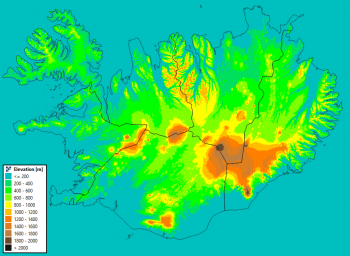
[[Image: | [[Image:Iceland_ElevationModel.png|right|thumb|350px|Image of the 10m DTM for Iceland. Credit: Contains elevation data from the National Land Survey of Iceland.]] | ||
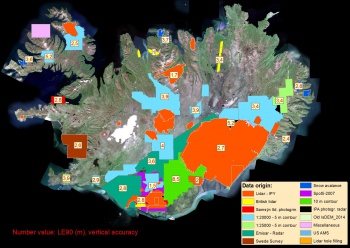
[[Image:Iceland_ElevationModel_Sources.jpg|right|thumb|350px|Sources for the 10m DTM for Iceland. Image Credit: National Land Survey of Iceland.]] | |||
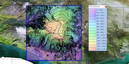
[[Image:IcelandDTM_AtSolheimajokull.png|right|thumb|450px|Example of Iceland DTM in windPRO: Area 40km x 40km at Sólheimajökull - with contour-lines at 50m separation.]] | |||
== Introduction == | == Introduction == | ||
Iceland LMI Elevation Model 2016 - 10m resolution (LMÍ Hæðarlíkan 2016): The National Land Survey of Iceland has released a DTM of Iceland - covering the whole country: This new DTM is an upgrade of an earlier DTM. The recent data added, which vary in origin, cover 39.100 km2 or some 38% of the country. | Iceland LMI Elevation Model 2016 - 10m resolution (LMÍ Hæðarlíkan 2016):<br>The National Land Survey of Iceland has released a DTM of Iceland - covering the whole country: This new DTM is an upgrade of an earlier DTM. The recent data added, which vary in origin, cover 39.100 km2 or some 38% of the country. As seen from the image below, this DTM is a multi-source mosaic. | ||
=== Dataset Overview === | === Dataset Overview === | ||
* '''Spatial Coverage''': Iceland | * '''Spatial Coverage''': Iceland | ||
* ''' | * '''Resolution''': 10m | ||
* '''Data type''': [[:Category%3ADigital_Elevation_Models#What_type_of_elevation_model.3F_DEM.2C_DSM_and_DTM.3F|Digital Terrain Model (DTM)]] | * '''Data type''': [[:Category%3ADigital_Elevation_Models#What_type_of_elevation_model.3F_DEM.2C_DSM_and_DTM.3F|Digital Terrain Model (DTM)]] | ||
* '''Coordinate System''': ISN93 / Lambert (EPSG:3057) | * '''Coordinate System''': ISN93 / Lambert (EPSG:3057) - in original data. | ||
* '''Version''': 2016 (with data | * '''Version''': 2016 (with data accessed in spring 2022) | ||
* '''Vertical accuracy''': Varies, see image to the right and usage notes below | * '''Vertical accuracy''': Varies, see image to the right and usage notes below | ||
== Usage Notes == | == Usage Notes == | ||
* An | * An alternative Icelandic elevation model (IcelandDEM version 1.0) is available from the National Land Survey of Iceland, that is based on stereo-imagery from satellites. | ||
* The vertical accuracy of the new (2016) data added are (see location on figure to the right): | * The vertical accuracy of the new (2016) data added are (see location on figure to the right): | ||
** Lidar data for the glaciers of Iceland (surveyed in the years 2007-2012), 15144 km2, LE90: 2.65 m. | |||
** Data from 5-m-contour lines, 10736 km2, LE90: 3.9 m. | |||
** Emisar radar data, 4536 km2, LE90: 3.2 m. | |||
** Data from 10-m-contour lines, 2938 km2, LE90: 8.48 m, | |||
** SwedeSurvey photogrammetic data, 1433 km2, LE90: 2.60 m, | |||
** 1:25.000 contour data, 1152 km2, LE90: 3.8 m, | |||
** British lidar data (courtesy of Dr. Susan Conway, Open University), 532 km2, LE90: 0.96-4.63 m. | |||
== Availability from within WindPRO == | == Availability from within WindPRO == | ||
Latest revision as of 12:03, 30 May 2022


Introduction
Iceland LMI Elevation Model 2016 - 10m resolution (LMÍ Hæðarlíkan 2016):
The National Land Survey of Iceland has released a DTM of Iceland - covering the whole country: This new DTM is an upgrade of an earlier DTM. The recent data added, which vary in origin, cover 39.100 km2 or some 38% of the country. As seen from the image below, this DTM is a multi-source mosaic.
Dataset Overview
- Spatial Coverage: Iceland
- Resolution: 10m
- Data type: Digital Terrain Model (DTM)
- Coordinate System: ISN93 / Lambert (EPSG:3057) - in original data.
- Version: 2016 (with data accessed in spring 2022)
- Vertical accuracy: Varies, see image to the right and usage notes below
Usage Notes
- An alternative Icelandic elevation model (IcelandDEM version 1.0) is available from the National Land Survey of Iceland, that is based on stereo-imagery from satellites.
- The vertical accuracy of the new (2016) data added are (see location on figure to the right):
- Lidar data for the glaciers of Iceland (surveyed in the years 2007-2012), 15144 km2, LE90: 2.65 m.
- Data from 5-m-contour lines, 10736 km2, LE90: 3.9 m.
- Emisar radar data, 4536 km2, LE90: 3.2 m.
- Data from 10-m-contour lines, 2938 km2, LE90: 8.48 m,
- SwedeSurvey photogrammetic data, 1433 km2, LE90: 2.60 m,
- 1:25.000 contour data, 1152 km2, LE90: 3.8 m,
- British lidar data (courtesy of Dr. Susan Conway, Open University), 532 km2, LE90: 0.96-4.63 m.
Availability from within WindPRO
The data are available directly from within windPRO in 10-meter resolution. The data can be accessed from the online-services in the following objects:
- Line Object (with purpose to height contour lines)
- Elevation Grid Object
Acknowledgement
- The LMI are thanked for producing this digital elevation dataset – and disseminating it in the public domain and thus for aiding the development of renewable energy - and wind energy in particular.
License
The product belongs to the open geo-data of Iceland - and it was released from the National Land Survey of Iceland according to the Creative Commons Attribution 4.0 International License. An attribution must be made when using data, such as:
Contains data from the Iceland LMI Elevation Model 2016 from the National Land Survey of Iceland (LMI)
Distribution through EMD and windPRO. CC BY 4.0.