EMD-WRF Europe+ (ERA5): Difference between revisions
| (17 intermediate revisions by 2 users not shown) | |||
| Line 23: | Line 23: | ||
== Availability as Atlas-Data == | == Availability as Atlas-Data == | ||
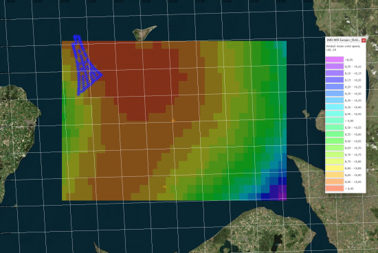
The EMD-WRF Europe+ (ERA5) dataset is available as atlas data through | [[Image:Denmark_AnholtAtlasARD.png|right|thumb|550px|EMD-WRF Europe+ as Atlas-Data - 80x60km area to the south-east of Anholt Wind Farm, Denmark]] | ||
The EMD-WRF Europe+ (ERA5) dataset is also available as [[:Category%3AAtlas_Data|atlas data]] through [https://www.emd-international.com/windpro/ windPRO] and [https://api.emd.dk/ EMD-API]. The atlas-data is provided in the standard [https://www.emd.dk/files/flow/EMD_technote_SITERES_20170515.pdf .siteres] format and can be used directly as analysis-ready-data (ARD) in windPRO within many modules: PARK, Site Compliance/Load Response and Optimization calculations. The atlas is pre-generated for a 15-year period (2004-2018). | |||
The [https://www.emd.dk/files/flow/EMD_technote_SITERES_20170515.pdf .siteres] file holds the following parameters: | '''DISCLAIMER:''' | ||
''The atlas-statistics have been calculated directly from the mesoscale-time-series data, suitable for offshore or 'simple' terrain locations. Special care should be taken when using these data for sites with significant microscale effects due to strong local orographic or roughness variations. In those cases, it is highly recommended to downscale the time-series directly using the [https://help.emd.dk/knowledgebase/content/windPRO4.0/c3-UK_windPRO4.0_ENERGY.html#pf1a windPRO downscaling feature] or using the [[GASP_Global|GASP]] dataset as an alternative. We also recommend to validate or adjust/calibrate the model using local ground-truth data, such as data from a meteorological mast or production data from wind turbines within the area of interest.'' | |||
The EMD-WRF Europe+ [https://www.emd.dk/files/flow/EMD_technote_SITERES_20170515.pdf .siteres]-file holds the following parameters: | |||
* Elevation | * Elevation | ||
* Air Density (heights: 50m, 75m, 100m, 150m, 200m) | * Air Density (heights: 50m, 75m, 100m, 150m, 200m) | ||
* Weibull: Omni-directional as well as 12 sectors (heights: 50m, 75m, 100m, 150m, 200m) | * Weibull: Omni-directional as well as 12 sectors (heights: 50m, 75m, 100m, 150m, 200m) | ||
The atlas-data are distributed using a geographical coordinate-system (EPSG:4326). The resampling and coordinate-transformation is | The atlas-data are distributed using a geographical coordinate-system (EPSG:4326). The resampling and coordinate-transformation is done automatically, using a nearest-neighbour approach and preserving a 3km spatial resolution in the centre-cell of the atlas (approx. 100 arc-second, 3km resolution). | ||
== More on Release Schedule and Availability == | == More on Release Schedule and Availability == | ||
Latest revision as of 07:46, 13 August 2024

Introduction
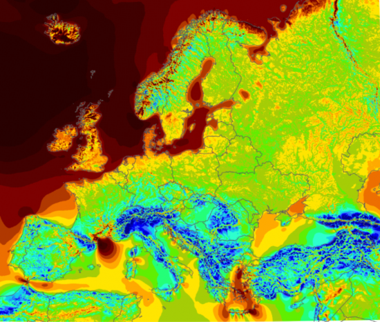
The EMD-WRF Europe+ (ERA5) dataset (or 'EMD-EUR+' for short) is our most accurate, high-resolution mesoscale dataset covering an Europe Plus domain. It is based on ERA-5 reanalysis data from ECMWF (http://www.ecmwf.int) as its boundary conditions. As a premium dataset, a ‘EMD-WRF Europe+ (ERA5)’ subscription gives you instant access to 2.5 million continuously updated onshore and offshore mesoscale time series. The domain area is shown in the figure to the right.
Direct access to time series via windPRO’s user friendly Online Data Service - i.e. no delivery time!
The WRF mesoscale model is run in an optimized configuration at a high spatial resolution of 3km to produce hourly time series. Spatial visualization of the full domain is included via windprospecting.com - and typically accessed from within windPRO.
The timespan of the data set is more than 20 years back and is accessed via windPRO’s user friendly interface to on-line data and requires payment of an annual subscription fee. The EMD-WRF Europe+ (ERA5) dataset is the successor of the EMD-ConWx Meso Data Europe.
ERA5(T) and ERA5 as forcing data in the EMD-WRF Europe+ (ERA) dataset
During early December 2019, ECMWF released the ERA5(T) dataset. ERA5(T) is preliminary ERA5 data, but updated with a shorter five calender day delay. From summer 2022, ECMWF did make the ERA5(T) data available for the native, reduced Gaussian grid. This is a major improvement over the previous release schedule (before summer 2022), where the ERA5 Gaussian grid data came with a 2-3 month delay/lag due to ECMWF releases. Read more about ERA5 and ERA5T on our ERA5(T) Rectangular Grid dataset-page. EMD-WRF Europe+ (ERA5) now uses both ERA5 (final) and ERA5(T) data, see more on the update schedule below.
Dataset Overview
- Content:: High-resolution and our most accurate mesoscale dataset covering an Europe+ domain.
127 different parameters with focus on renewable energy applications. - Spatial Resolution: 3km
- Temporal Resolution: Hourly.
- Coverage: See image to the right. Coverage is a pan-european domain.
- Period: 20+ years - the EMD databases holds data from 1999 until present day.
- Update schedule:
- Currently, EMD is updating this dataset once a month. The mesoscale dataset is available around the 20th of the month, where all data from the previous month will be available. The actual date may vary, as it depends on the availability of the forcing data (ERA5 from ECMWF) and high-performance computing time.
- Once the final ERA5 data becomes available (after 2-3 months) a check will be made if the final data released by ECMWF differs from the preliminary data. If so, the data will be updated but according to ECMWF they do not expect changes to happen very often - and in the event that it does happen - it will be communicated to users. At EMD we will communicate any such changes to the windPRO users as well.
Availability as Atlas-Data

The EMD-WRF Europe+ (ERA5) dataset is also available as atlas data through windPRO and EMD-API. The atlas-data is provided in the standard .siteres format and can be used directly as analysis-ready-data (ARD) in windPRO within many modules: PARK, Site Compliance/Load Response and Optimization calculations. The atlas is pre-generated for a 15-year period (2004-2018).
DISCLAIMER: The atlas-statistics have been calculated directly from the mesoscale-time-series data, suitable for offshore or 'simple' terrain locations. Special care should be taken when using these data for sites with significant microscale effects due to strong local orographic or roughness variations. In those cases, it is highly recommended to downscale the time-series directly using the windPRO downscaling feature or using the GASP dataset as an alternative. We also recommend to validate or adjust/calibrate the model using local ground-truth data, such as data from a meteorological mast or production data from wind turbines within the area of interest.
The EMD-WRF Europe+ .siteres-file holds the following parameters:
- Elevation
- Air Density (heights: 50m, 75m, 100m, 150m, 200m)
- Weibull: Omni-directional as well as 12 sectors (heights: 50m, 75m, 100m, 150m, 200m)
The atlas-data are distributed using a geographical coordinate-system (EPSG:4326). The resampling and coordinate-transformation is done automatically, using a nearest-neighbour approach and preserving a 3km spatial resolution in the centre-cell of the atlas (approx. 100 arc-second, 3km resolution).
More on Release Schedule and Availability
Data is updated monthly with approximately 3 weeks delay defined by ERA-5's availability (from ECMWF), download time from the Copernicus Climate Datastore (from EU-Storage Servers) and computational efforts regarding EMD's high-performance computer clusters (from EMD). Before contacting support because of delays in the release schedule, please check ERA-5's availability on the ERA5 availability page (see link below). 'EMD-WRF Europe+ (ERA5)' data cannot be computed at EMD HPC before ERA-5 data is available and have been downloaded to our storage system.
Validation
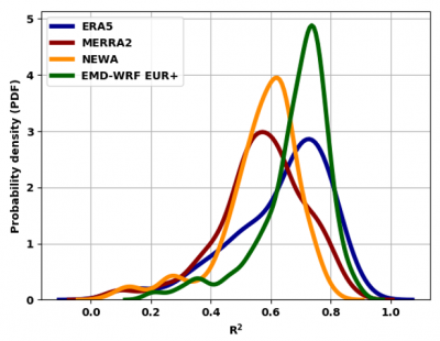
The model-setup has been thoroughly validated by EMD using 300 high-quality meteorological masts spatially distributed in the modelling domain. The performance is documented in this detailed validation report (see Validation Report) - and briefly summarized in the graph below.

In addition to the EMD-validations, the general EMD-WRF modelling setup has been evaluated in a number of external benchmarks. We have a separate EMD-WRF Benchmark Wiki-Page that holds links to those investigations. If you complete a benchmark study with EMD-WRF data then please let us know - (see contact information here) - and we will add your reference to our benchmark page.
Dataset Parameters
A total of 127 sensors (parameters) are ready available for in-depth analysis directly in windPRO. The different parameters in the EMD-WRF Europe+ (ERA5) dataset that are available from within windPRO are shown in the table below.
| Parameter | Unit | Description | Type |
|---|---|---|---|
| time | UTC time stamp (YYYY-MM-DD HH:MM) | ||
| wSpeed.x | m/s | Wind speeds at different heights above ground (x). Heights (x): 10,25,50,75,100,150,200,300,400,500,750,1000,4000m |
Instantaneous |
| wDir.x | deg | Wind directions at different heights above ground (x). Heights (x): 10,25,50,75,100,150,200,300,400,500,750,1000,4000m |
Instantaneous |
| sqrtTKE.x | m/s | Wind speed given as standard deviation in m/s. Derived from the turbulent kinetic energy (TKE) at different heights above ground (x). Use with caution, and avoid use for site assessment and loads as variability is underestimated. Heights (x): 10,25,50,75,100,150,200,300,400,500,750,1000,4000m |
Instantaneous |
| press.x | Pa | Pressure at different heights above ground (x). Heights (x): 10,25,50,75,100,150,200,300,400,500,750,1000,4000m |
Instantaneous |
| temp.x | celcius | Temperature at different heights above ground (x). Heights (x): 10,25,50,75,100,150,200,300,400,500,750,1000,4000m |
Instantaneous |
| rh.x | % | Relative humidity at different heights above ground (x). Heights (x): 10,25,50,75,100,150,200,300,400,500,750,1000,4000m |
Instantaneous |
| cloudWater.x | mg/kg | Cloud water content at different heights above ground (x). Heights (x): 10,25,50,75,100,150,200,300,400,500,750,1000,4000m |
Instantaneous |
| cloudIce.x | mg/kg | Cloud icing content at different heights above ground (x). Heights (x): 10,25,50,75,100,150,200,300,400,500,750,1000,4000m |
Instantaneous |
| psfc | Pa | Pressure at site | Instantaneous |
| msl | Pa | Pressure at mean sea level | Instantaneous |
| wSpeed.850hpa | m/s | Wind speeds at pressure level 850hPa. | Instantaneous |
| wDir.850hpa | deg | Wind speeds at pressure levels 850hPa. | Instantaneous |
| temperature.2 | celcius | Temperatures at 2m | Instantaneous |
| waterTemp | celcius | Water temperature | Instantaneous |
| soilTemp.0-10cm | celcius | The temperature in the upper 10 cm of the soil | Instantaneous |
| relHumidity.2 | % | Relative humidity in height 2m above ground level | Instantaneous |
| snowDepth | m | Snow depth (if present) | Instantaneous |
| vis.s | m | Visibility at surface | Instantaneous |
| sensHeatFlux.s | w/m2 | Sensible Heat Flux at surface | Instantaneous |
| totPrecip.s | kg/m^2 | Total Precipitation at surface | 1h Accumulated |
| downShortWaveFlux.s | w/m2 | Downward shortwave irradiance at surface | 1h Average |
| swdDir.s | w/m2 | Direct shortwave irradiance at surface | 1h Average |
| swdDif.s | w/m2 | Diffuse shortwave irradiance at surface | 1h Average |
| cloudBottom | m | Height of cloud bottom | Instantaneous |
| cloudTop | m | Height of cloud top | Instantaneous |
| totalCloudCover.a | % | Total cloud cover in atmosphere | 1h Average |
| convCloudCover.a | % | Convective cloud cover in atmosphere | 1h Average |
| rmol | 1/m | Inverse Monin-Obukhov-Length | |
| znt | m | Rougnhess length | Instantaneous |
| u* | m/s | U-start (friction velocity) | Instantaneous |
| pblh | m | Height of the PBL boundary layer | Instantaneous |
Required Modules/Licenses
To access the EMD-WRF Europe+ (ERA5) mesoscale data the following licenses/modules are required in your windPRO setup:
- Basis
- METEO
- EMD-WRF Europe+ (ERA5)
When the license fee is paid, you then have access to the full dataset without further cost. The price is available from the price-list on the EMD-homepage. Downloading of data is unrestricted for licenced users, however, a "fair use" policy applies. Unlicenced users may download three months of data from any point, however, multiple downloads are not allowed from the same point. With a license to the EMD-WRF Europe+ dataset, you will also have free access to its predecessor, the EMD-ConWx dataset for Europe.
Visit EMD online ordering to purchase the needed licences.
Acknowledgement
- Model development and integration of this dataset into EMD services - was co-supported through the WindPROSPER project. The windPROSPER project is co-funded by the Danish Innovation Fund and the EuroStars framework programme.
Attribution
If data from this dataset is used within any private or public disseminations, then EMD and its data providers must be acknowledged.
Source:
EMD-WRF Europe+ (ERA5) - Copyright (c) - EMD International A/S, 2019. Distribution through EMD and windPRO.
This dataset uses ERA5 which is being developed through the Copernicus Climate Change Service (C3S).
Data processing and distribution for ERA5 is carried out by ECMWF.
External Links
- WindPROSPER at Eurostars
- Innovation Fund Denmark - https://innovationsfonden.dk
- ERA5 availability page: : https://cds.climate.copernicus.eu/cdsapp#!/dataset/reanalysis-era5-single-levels?tab=form