EMD-ConWx Meso Data Europe: Difference between revisions
No edit summary |
|||
| Line 14: | Line 14: | ||
* MCP | * MCP | ||
* EMD-ConWx Meso Data, Europe | * EMD-ConWx Meso Data, Europe | ||
When the license fee is | When the license fee is paid, then you have access to the full data-set without further cost. The cost is available from the [http://www.emd.dk/WindPRO/Price%20List/ price-list on the EMD-homepage]. | ||
== Model Domain == | == Model Domain == | ||
Revision as of 22:29, 26 May 2013

WindPRO 2.9 introduces a high resolution Meso scale data set covering Europe. The data are modeled and computed in-house - in collaboration between EMD and ConWx (http://www.conwx.com) who are experts in Meso scale modelling.
Note: This data-set requires an additional license to use (see below).
Dataset Description
The Meso scale model is run at a high spatial resolution of 0.03°x0.03°, approximately 3x3 km with hourly temporal resolution. ERA Interim data from ECMWF (http://www.ecmwf.int) is the global boundary data set. Timespan is at least 10 years back, extended to cover minimum 20 years during 2013. Data are updated monthly with approximate 3 months delay defined by ERA Interims availability and computational efforts at EMD high-performace computer clusters.
Data access is via WindPRO’s user friendly interface to on-line data and payment of an annual subscription fee.
Required modules/licenses
To access the EMD-ConWx Meso scale data the following licenses/modules are required in your WindPRO setup:
- Basis
- MCP
- EMD-ConWx Meso Data, Europe
When the license fee is paid, then you have access to the full data-set without further cost. The cost is available from the price-list on the EMD-homepage.
Model Domain
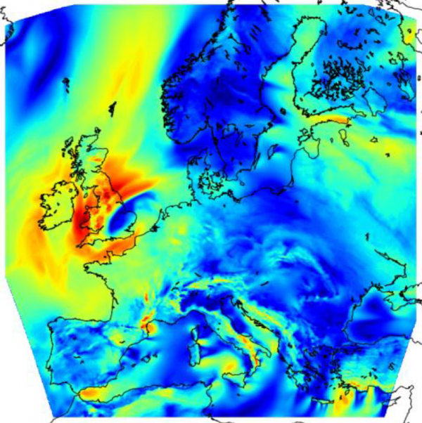
The model domain for the EMD-ConWx model is shown in the figure below. Our new data set covers Europe including larger parts of Turkey and Ukraine, excluding the northern extreme of Scandinavia.

Dataset Parameters
A large quantity of useful parameters are available directly in WindPRO to aid your analysis. The different parameters in the EMD-ConWx dataset that is available from within WindPRO is shown in the table below.
| Parameter | Description |
|---|---|
| time | UTC time stamp |
| psfc | Pressure at site [hPa] |
| msl | Pressure at mean sea level [hPa] |
| wSpeed.x | Wind speeds at different physical levels (x). Heights (x): 10m, 25m, 50m, 75m, 100m, 150m, 200m |
| wDir.x | Wind speeds at different physical levels (x). Heights (x): 10m, 25m, 50m, 75m, 100m, 150m, 200m |
| wSpeed.0-30mb | Wind speeds at pressure level 0-30mb. |
| wDir.0-30mb | Wind speeds at pressure levels 0-30mb. |
| wSpeed.850hpa | Wind speeds at pressure level 850hPa. |
| wDir.850hpa | Wind speeds at pressure levels 850hPa. |
| temperature.x | Temperatures at different heights (x) Heights (x): 2m and 100m |
| waterTemp | To be completed |
| soilTemp.0-10cm | To be completed |
| relHumidity.2 | To be completed |
| snowDepth | To be completed |
| vis.s | To be completed |
| sensHeatFlux.s | To be completed |
| totPrecip.s | To be completed |
| downShortWaveFlux.s | To be completed |
| totalCloudCover.a | To be completed |
| convCloudCover.a | To be completed |
| 4LFTX | To be completed |
| rmol | To be completed |
| znt | To be completed |
Model Experiences
The model-setup has been validated through various internal investigations on masts around Europe. Direct comparison against a tall Danish mast at Høvsøre is found on the second page of the EMD-ConWx Meso datasheet available.
EMD and some users has found that the absolute levels of the wind speeds may be 10%-15% off at some Central European locations. However, note, that this data-set was not designed to replace a mast but rather intended for long-term corrections of local masts. For this purpose we have excellent experience with the use of the data – the absolute level do not need to be correct, as long it is consistent.
For the absolute levels to be (more) correct and potentially useful for direct micro-siting analysis', the need to incorporate a down-scaling procedure and further proper utilizing a micro-scale model with associated micro-scale data is currently being investigated (2013).