Glob Cover: Difference between revisions
No edit summary |
No edit summary |
||
| Line 2: | Line 2: | ||
== Introduction == | == Introduction == | ||
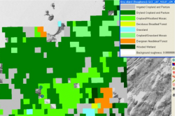
[[File: GLCCandWindPRO.png|right|thumb|250px|GlobCover Roughness Data in WindPRO]]GlobCover is an ESA initiative which began in 2005 in partnership with JRC, EEA, FAO, UNEP, GOFC-GOLD and IGBP. The aim of the project was to develop a service capable of delivering global composites and land cover maps using as input observations from the 300m MERIS sensor on board the ENVISAT satellite mission. ESA makes available the land cover maps, which cover 2 periods: December 2004 - June 2006 and January - December 2009. See more at: http://due.esrin.esa.int/globcover/ | [[File: GLCCandWindPRO.png|right|thumb|250px|GlobCover Roughness Data in WindPRO]]GlobCover is an ESA initiative which began in 2005 in partnership with JRC, EEA, FAO, UNEP, GOFC-GOLD and IGBP. The aim of the project was to develop a service capable of delivering global composites and land cover maps using as input observations from the 300m MERIS sensor on board the ENVISAT satellite mission. ESA makes available the land cover maps, which cover 2 periods: December 2004 - June 2006 and January - December 2009. See more at: http://due.esrin.esa.int/globcover/ | ||
There is a validation report available at: http://due.esrin.esa.int/globcover/LandCover2009/GLOBCOVER2009_Validation_Report_2.2.pdf | |||
== Coverage == | == Coverage == | ||
This dataset has a global coverage. It is based on a | This dataset has a global coverage (except for the arctics). It is based on a 300 m x 300 m grid. | ||
== Legends == | == Legends == | ||
The Globcover dataset has 23 different categories that EMD has mapped in to a suggest roughness length, z0. | |||
<center> | <center> | ||
| Line 115: | Line 117: | ||
== License and Acknowledgement == | == License and Acknowledgement == | ||
When using the dataset please use the following acknowledgement: | |||
Global land cover data: © ESA 2010 and UCLouvain | |||
http://due.esrin.esa.int/ | |||
== External Link == | == External Link == | ||
http://due.esrin.esa.int/globcover/ | |||
Revision as of 13:06, 29 July 2014
Introduction

GlobCover is an ESA initiative which began in 2005 in partnership with JRC, EEA, FAO, UNEP, GOFC-GOLD and IGBP. The aim of the project was to develop a service capable of delivering global composites and land cover maps using as input observations from the 300m MERIS sensor on board the ENVISAT satellite mission. ESA makes available the land cover maps, which cover 2 periods: December 2004 - June 2006 and January - December 2009. See more at: http://due.esrin.esa.int/globcover/
There is a validation report available at: http://due.esrin.esa.int/globcover/LandCover2009/GLOBCOVER2009_Validation_Report_2.2.pdf
Coverage
This dataset has a global coverage (except for the arctics). It is based on a 300 m x 300 m grid.
Legends
The Globcover dataset has 23 different categories that EMD has mapped in to a suggest roughness length, z0.
| ID | Land Cover Type | EMD Roughness Class |
|---|---|---|
| 1 | Urban and Built-Up Land | z0=0.400 |
| 2 | Dryland Cropland and Pasture | z0=0.100 |
| 3 | Irrigated Cropland and Pasture | z0=0.100 |
| 4 | Mixed Dryland/Irrigated Cropland and Pasture | z0=0.100 |
| 5 | Cropland/Grassland Mosaic | z0=0.070 |
| 6 | Cropland/Woodland Mosaic | z0=0.150 |
| 7 | Grassland | z0=0.050 |
| 8 | Shrubland | z0=0.070 |
| 9 | Mixed Shrubland/Grassland | z0=0.060 |
| 10 | Savanna | z0=0.070 |
| 11 | Deciduous Broadleaf Forest | z0=0.400 |
| 12 | Deciduous Needleleaf Forest | z0=0.400 |
| 13 | Evergreen Broadleaf Forest | z0=0.500 |
| 14 | Evergreen Needleleaf Forest | z0=0.500 |
| 15 | Mixed Forest | z0=0.400 |
| 16 | Water Bodies | z0=0.0002 |
| 17 | Herbaceous Wetland | z0=0.030 |
| 18 | Wooded Wetland | z0=0.100 |
| 19 | Barren or Sparsely Vegetated | z0=0.020 |
| 20 | Herbaceous Tundra | z0=0.050 |
| 21 | Wooded Tundra | z0=0.150 |
| 22 | Mixed Tundra | z0=0.100 |
| 23 | Bare Ground Tundra | z0=0.030 |
| 24 | Snow or Ice | z0=0.001 |
License and Acknowledgement
When using the dataset please use the following acknowledgement:
Global land cover data: © ESA 2010 and UCLouvain http://due.esrin.esa.int/