ERA5 Gaussian Grid: Difference between revisions
| Line 175: | Line 175: | ||
== ERA5 and EMD-WRF Mesoscale Services == | == ERA5 and EMD-WRF Mesoscale Services == | ||
EMD is currently working to include ERA5 | EMD is currently working to include ERA5 boundary data to the portfolio of EMD-WRF Mesoscale sources and services [https://www.emd.dk/windpro/mesoscale-data/ here]. | ||
== External Links == | == External Links == | ||
Revision as of 12:33, 30 August 2017

Introduction
ERA5 is a climate reanalysis dataset developed through the Copernicus Climate Change Service (C3S) and processed/delivered by ECMWF. The dataset is intended to replace the ERA-Interim dataset from ECMWF shortly after the ERA5 dataset is complete. The ERA5 dataset has several improvements compared to ERA-Interim:
- Newer modelling system
- More observations used in the assimilation
- Higher spatial horizontal resolution (around 31 km compared to 79 km)
- Higher spatial vertical resolution
More information is available in the windPRO Online Data release note from august 2017. A comparison to ERA-Interim and MERRA 2 is also included in this note. here.
Resolution, Coverage and Evaluation

Resolution:
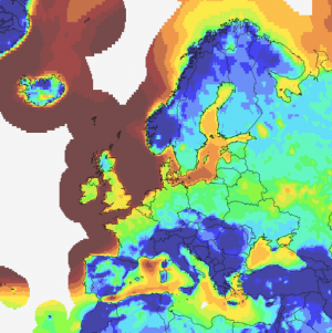
The model grid is a reduced gaussian grid (T620) which has a lateral resolution of 0.28125 (around 31 km). It holds 1 hourly values. Coverage is global for land-areas and coastal regions. In windPRO, offshore coverage is expected up to cover and area of approximately 300 km from the coastline.
Data Evaluation:
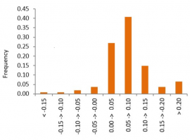
The hourly wind speeds from ERA5 and MERRA2 data have been compared to measured wind speeds from 108 tall meteorological masts around the globe. The masts have sensor heights ranging from about 60m to 140m. The correlation has been calculated for all sites - and ERA5 data shows a significant improvement over MERRA2 – the average correlation is increased with 0.07 and the variation is also lower.
Further information in the release note, here.
Release Plan

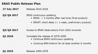
The release of the remaining parts of ERA5 is following the schedule from C3S and ECMWF (see the image to the right). The first batch of data covers the period of 2010-2016. It was released during summer 2017. Data from 2017+ and later with a monthly update cycle will be available from 2017-Q3/Q4. The batch of data from 1979-2009 is planned at 2018-Q2. The period dating back to 1950 will be available in 2019. EMD will release ERA5 in windPRO as soon as it is available.
Data Parameters
EMD extracts a focused subset of climate-parameters from the ERA5 datasets - this subset focuses on wind-energy modelling. When the data have been processed at EMD, then the following parameters are available from within the online-data services within windPRO.
| Parameter | Unit | Description |
|---|---|---|
| time | UTC time stamp | |
| wSpeed.10 | m/s | Wind speed @ 10m |
| wDir.10 | deg | Wind direction @ 10m |
| wSpeed.10n | m/s | Neutral wind speed @ 10m |
| wDir.10n | deg | Neutral wind direction @ 10m |
| wSpeed.100 | m/s | Wind speed @ 100m |
| wDir.100 | deg | Wind direction @ 100m |
| temperature.2 | deg.celcius | Temperature @ 2m |
| dewPointTemp.2 | deg.celcius | Dew point temperature @ 2m |
| rh.2 | % | Relative humidity @ 2m |
| psfc | pa | Surface pressure |
| msl | pa | Mean sea-level pressure |
| sst | deg.celcius | Sea surface temperature |
| blh | m | Boundary layer height |
| tcc | % | Total cloud cover |
| fsr | m | Forecast surface roughness |
| tclw | kg/m2 | Total column liquid water |
| tciw | kg/m2 | Total column ice water |
| charnock | ~ | Charnock |
| heatFlux | w/m2 | Instantaneous surface sensible heat flux |
| lowCc | % | Low cloud cover |
| medCc | % | Medium cloud cover |
| hiCc | % | High cloud cover |
| eastTss | N m**-2 | Instantaneous eastward turbulent surface stress |
| northTss | N m**-2 | Instantaneous northward turbulent surface stress |
| zust | m/s | Friction velocity |
| cbh | m | Cloud base height |
| uvbAcc | w/m2 | Downward UV radiation at the surface |
| sshfAcc | w/m2 | Surface sensible heat flux |
| ssrdAcc | w/m2 | Surface solar radiation downwards |
| ssrAcc | w/m2 | Surface net solar radiation |
| ssrcAcc | w/m2 | Surface net solar radiation, clear sky |
| tisrAcc | w/m2 | TOA incident solar radiation |
| fdirAcc | w/m2 | Total sky direct solar radiation at surface |
| cdirAcc | w/m2 | Clear-sky direct solar radiation at surface |
| ssrdcAcc | w/m2 | Surface solar radiation downward clear-sky |
ERA5 and EMD-WRF Mesoscale Services
EMD is currently working to include ERA5 boundary data to the portfolio of EMD-WRF Mesoscale sources and services here.
External Links
- ECMWF - What is ERA5 - https://software.ecmwf.int/wiki/display/CKB/What+is+ERA5
- Copernicus Climate Change Service - ERA5 Page - https://climate.copernicus.eu/products/climate-reanalysis
Acknowledgements and Credits
- ERA5 is being developed through the Copernicus Climate Change Service (C3S).
- Data processing and distribution for ERA5 is carried out by ECMWF.