KNMI North Sea Wind (KNMI-KNW): Difference between revisions
m (Morten moved page KNMI-KNW to KNMI-KNW (KNMI North Sea Wind)) |
mNo edit summary |
||
| Line 1: | Line 1: | ||
[[Category:Online Data]][[Category:Wind Data]] | [[Category:Online Data]][[Category:Wind Data]] | ||
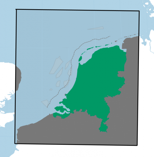
[[Image:KNW-DomainEMD.png|right|thumb|500px|Data Domain for the KNMI-KNW North Sea Winds Dataset]] | |||
==Introduction== | ==Introduction== | ||
KNMI-KNW North Sea Winds is a high resolution mesoscale dataset that is | KNMI-KNW North Sea Winds is a high resolution mesoscale dataset that is modeled and provided by the Royal Netherlands Meteorological Institute, KNMI. The dataset has a spatial coverage that holds the Netherlands along with its nearby North Sea area, see the black rectangle in figure to the right. | ||
==Dataset Description== | ==Dataset Description== | ||
| Line 11: | Line 11: | ||
==Required windPRO Modules== | ==Required windPRO Modules== | ||
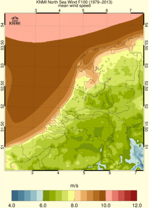
This dataset can be accessed to the most recent version of windPRO given that you hold an active service agreement and a license to the following modules: | [[Image:AverageWindSpeedinKNW.png|right|thumb|500px|Mean Wind Speed 1979-2013 for KNW]]This dataset can be accessed to the most recent version of windPRO given that you hold an active service agreement and a license to the following modules: | ||
* Basis | * Basis | ||
* Meteo | * Meteo | ||
Revision as of 13:33, 24 September 2018

Introduction
KNMI-KNW North Sea Winds is a high resolution mesoscale dataset that is modeled and provided by the Royal Netherlands Meteorological Institute, KNMI. The dataset has a spatial coverage that holds the Netherlands along with its nearby North Sea area, see the black rectangle in figure to the right.
Dataset Description
The KNMI-KNW wind atlas is developed using the HARMONIE mesoscale model – and it uses the ERA-Interim reanalysis dataset as its boundary data. The spatial resolution is 2.5km – and data from the 31960 individual nodes are available in windPRO as hourly time series. The dataset holds data that dates back to 1979. The vertical profile of wind speed was calibrated against the 200 m tall Cabauw measurement mast to obtain a single wind shear correction coefficient; this correction was applied by KNMI throughout the whole dataset.
Data Domain
A map of the boundaries for the data is seen as in the figure to the right. Boundaries for this dataset are (in geographical coordinates): Lower-left node (N50.29, E1.46). Upper right node: (N54.63, E8.00).
Required windPRO Modules

This dataset can be accessed to the most recent version of windPRO given that you hold an active service agreement and a license to the following modules:
- Basis
- Meteo
Release Schedule
This dataset is updated on a monthly basis by KNMI – the data is available with approximately 3 months delay as defined by ERA Interim’s availability. When new data has been made available by KNMI it is processed by EMD, then released as a part of the windPRO online datasets.
Dataset Parameters
The following parameters are available from the KNMI-KNW mesoscale dataset
Dataset License
This dataset has been released from KNMI as free and open dataset. The license referred is CCO 1.0, which can be accessed here: https://creativecommons.org/publicdomain/zero/1.0/deed.en
External Links and References
- KNMI-KNW at KNMI Data Centre: https://data.knmi.nl/datasets?q=knw
- KNMI-KNW Description: http://projects.knmi.nl/knw/data/
- KNW User Manual (pdf-format)
Acknowledgement and Credits
Credits and Acknowledgement: Royal Netherlands Meteorological Institute, KNMI for the release and maintenance of the KNMI-KNW dataset.