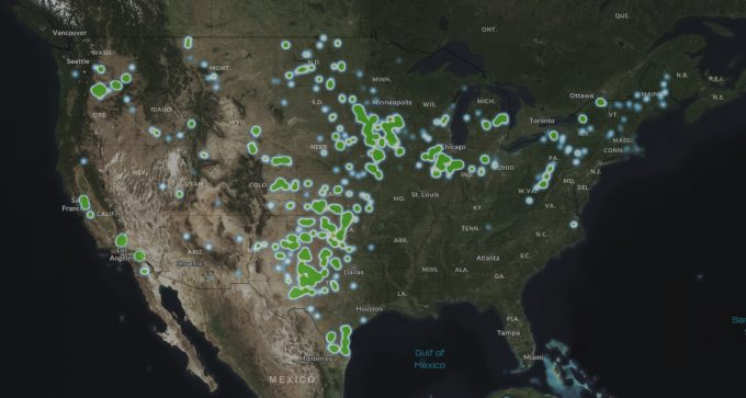
US Wind Turbines
Introduction
A database of existing wind turbines in the United States is available for import in windPRO using Data -> Online WTG Data. The database has been published by the U.S. Geological Survey (http://usgs.gov) and consists of 74.511 wind turbines as of May 2024. Turbine positions have been verified by U.S. Geological Survey using visual interpretation of high-resolution aerial imagery. The database was started back in 2016, where USGS, LBNL, and the American Wind Energy Association (AWEA, the predecessor of ACP) began collaborating on development of the USWTDB.
History (versions) in windPRO
- 2024-06-27 - Updated to version USWTDB_V7_0_20240510
- 2020-09-06 - Update of USWTDB added to windPRO
July 2013.
Coverage
The database covers United States. Note that offshore wind farms are not included. See the interactive map displaying coverage.
The wind turbines in windPRO
The majority of the wind turbines (50.12%) in this database have been mapped to wind turbines in the windPRO WTG catalogue and as such the imported WTG object will have the correct type, rated power, hub height and rotor diameter.
In situations where the imported WTG type is unknown, the WTG object will still be created in the correct position and the description of the object will be:
Not found: <Manufacturer> <Rated Power> <Rotor diameter> <Hub height>
(Depending on the availability of additional information about this particular wind turbine)
When information is available, it is added to the WTG Objects description tab, for example:
- Source Unique Identifiers
- Attribute and location confidence
- Image source used
- Project name
- State and county
Citation
Diffendorfer, J.E., Compton, Roger, Kramer, Louisa, Ancona, Zach, and Norton, Donna, 2014, Onshore industrial wind turbine locations for the United States through July 2013: U.S. Geological Survey Data Series 817, http://dx.doi.org/10.3133/ds817.
ISSN 2327-638x (online)
External Links
Interactive map: https://eerscmap.usgs.gov/uswtdb/viewer/#3/37.25/-96.25
Data source : https://eerscmap.usgs.gov/uswtdb/
Additional information: http://pubs.usgs.gov/ds/817/
