EMD-WRF India

Introduction and Model Domain
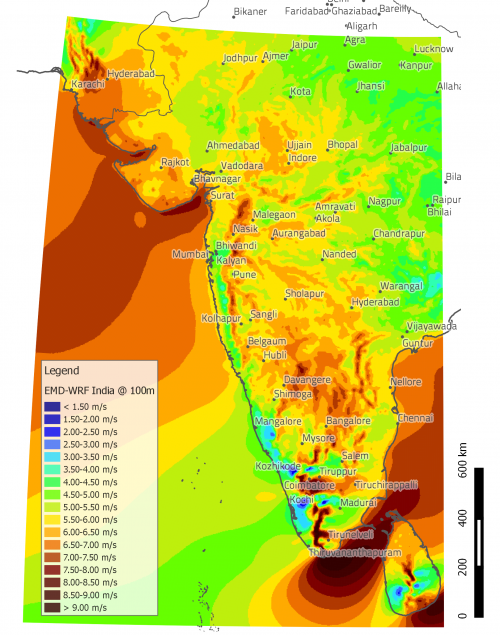
EMD-WRF India is a high resolution mesoscale dataset modelled and provided by EMD International A/S. The dataset covers major part of India, all of Sri Lanka and parts of Pakistan. The model domain for EMD-WRF India is shown in the figure to the right.
Note: This dataset requires an additional license (see below).
Dataset Description
The mesoscale model is run at a spatial resolution of 0.029°x0.029°, approximately 3x3 km, and with hourly temporal resolution. ERA Interim data from ECMWF (http://www.ecmwf.int) is the global boundary data. The timespan of the data is back to 1994 and up until the latest available boundary data (see below for the Release Schedule). Data access is via WindPRO’s user friendly interface to on-line data and requires payment of an annual subscription fee.
Release Schedule
Data is updated monthly with approximately 3 months delay defined by ERA Interim's availability. Before contacting support because of delays in the release schedule, please check ERA interim's availability on the ERA availability page. EMD-WRF India data cannot be computed before ERA interim data is available.
When downloading the most recent data, please note that the last day of the last month will be missing until the next month is added. This is because, in order to compute a full day of data, the 24:00h (or 0:00 of following day) time stamp is required, but the last time stamp of a month in ERA interim data is 18:00 h.
Validation
The model-setup has been validated through various internal investigations on masts spatially distributed in the modelling area.
The findings (the correlations) are summarized in the product datasheet available (here).
In addition, the EMD-WRF modelling setup has been evaluated in a number of external benchmarks.
We have a separate EMD-WRF Benchmark Wiki-Page that holds links to those investigations.
Required modules/licenses
To access the EMD-ConWx meso-scale data the following licenses/modules are required in your WindPRO setup:
- Basis
- METEO
- EMD-WRF India
When the license fee is paid, you then have access to the full dataset without further cost. The price is available from the price-list on the EMD-homepage. Downloading of data is unrestricted for licenced users, however, a "fair use" policy applies. Unlicenced users may download three months of data from any point, however, multiple downloads are not allowed from the same point.
Visit EMD online ordering to purchase the needed licences.
Dataset Parameters
A large quantity of useful parameters are available directly in WindPRO to aid in your analysis.
The different parameters in the EMD-WRF India dataset that are available from within WindPRO are shown in the table below.
| Parameter | Unit | Description | Type |
|---|---|---|---|
| time | UTC time stamp | ||
| psfc | hPa | Pressure at site | Instantaneous |
| msl | hPa | Pressure at mean sea level | Instantaneous |
| wSpeed.x | m/s | Wind speeds at different physical levels (x). Heights (x): 10m, 25m, 50m, 75m, 100m, 150m, 200m |
Instantaneous |
| wDir.x | deg | Wind speeds at different physical levels (x). Heights (x): 10m, 25m, 50m, 75m, 100m, 150m, 200m |
Instantaneous |
| wSpeed.0-30mb | m/s | Wind speeds at pressure level 0-30mb. | Instantaneous |
| wDir.0-30mb | deg | Wind speeds at pressure levels 0-30mb. | Instantaneous |
| wSpeed.850hpa | m/s | Wind speeds at pressure level 850hPa. | Instantaneous |
| wDir.850hpa | deg | Wind speeds at pressure levels 850hPa. | Instantaneous |
| temperature.x | celcius | Temperatures at different heights (x) Heights (x): 2m and 100m |
Instantaneous |
| waterTemp | celcius | Water temperature | Instantaneous |
| soilTemp.0-10cm | celcius | The temperature in the upper 10 cm of the soil | Instantaneous |
| relHumidity.2 | % | Relative humidity in height 2m above ground level | Instantaneous |
| snowDepth | m | Show depth (if present) | Instantaneous |
| vis.s | m | Visibility at surface | Instantaneous |
| sensHeatFlux.s | w/m2 | Sensible Heat Flux at surface | Instantaneous |
| totPrecip.s | kg/m^2/s | Total Precipitation at surface | 1h Average |
| downShortWaveFlux.s | w/m2 | Downward shortwave irradiance at surface | 1h Average |
| totalCloudCover.a | % | Total cloud cover in atmosphere | 1h Average |
| convCloudCover.a | % | Convective cloud cover in atmosphere | 1h Average |
| Data below this line are not shown in a default import of EMD-WRF India data, but can be made available by clicking on the "+" button in the lower left corner of the import table. | |||
| 4LFTX | K | N/A | |
| rmol | 1/m | Inverse Monin-Obukhov-Length [1] | |
| znt | m | Rougnhess length | |
| sqrtTKE.x | m/s | Wind speed given as standard deviation in m/s. Derived from the turbulent kinetic energy (TKE). Results available in different physical levels. Heights (x): 10m, 25m, 50m, 75m, 100m, 150m, 200m |
Instantaneous |
| cloudWater.100 | kg/kg | Parameter intended for estimating probability of icing.[2] | Instantaneous |
| cloudIce.100 | kg/m^2 | Parameter intended for estimating probability of icing. [2] | Instantaneous |
Footnotes
- ↑ It is still being investigated whether this inverse Monin-Obukhov-Length can be used for stability clasification.
- ↑ 2.0 2.1 CloudWater and cloudIcing values are extracted directly from the WRF meso-scale model and are normal output parameters of the same run as the other parameters (wind, temperature etc.). They are controlled by the WRF microphysics scheme for which Ferrier was used. For further information, please access the numerous internet resources about WRF use. EMD has not done any validation on the parameters, so they are provided as is.