UK-OS Terrain 50
Introduction

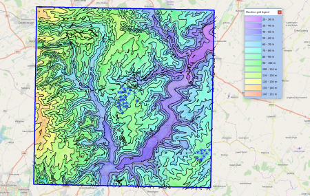
OS Terrain 50 is a digital elevation dataset for Great Britain – actively maintained by the Ordnance Survey: Two versions of the dataset exist: one vector-dataset that provides height contours with a 10 m vertical spacing and one gridded dataset with a grid-spacing of 50 m. The resolution of the dataset corresponds to a 1:50000 mapping scale. Update frequency is once a year – in July. The version delivered with windPRO is from 2014.
Coverage
Coverage is for the whole of Great Britain (not including Northern Ireland).
Usage Notes
- For projects in Northern Ireland, we recommend the OSNI Open-Data 10m gridded digital elevation dataset.
- For projects in Wales - also consider the LiDAR dataset available in the Wales Elevation Model.
- Need higher resolution data? OS maintains a commercial, higher resolution dataset 'OS Terrain 5'
- The user guide and technical specification for the OS Terrain 50 dataset is available here in this pdf-file.
Availability in WindPRO
The 'OS Terrain 50' data can be accessed from the online-services in the following objects:
- Line Object (with purpose to height contour lines)
- Elevation Grid Object
Licence
The data is distributed according to the OS OpenData terms . Please take proper care to add proper atribution in order to acknowledge the source of information. Typically, this is done by adding the following statement to your report-picture or map:
Credit: Contains OS data © Crown copyright and database right 2018. Distribution through EMD and windPRO.
Acknowledgements
- The UK Ordnance Survey and the public of UK are thanked for producing this digital elevation dataset – and disseminating it in the public domain and thus for aiding the development of renewable energy.
Raw Data Types
- Raw vector data is stored in shape file format or GML3.2.
- Grid data is stored in either ASCII-Grid or GML3.2.
External Links
- Original data is available from the ‘OS Terrain 50’ web-page of the Ordnance Survey https://www.ordnancesurvey.co.uk/business-and-government/products/terrain-50.html.
- OS FAQ on OS Terrain 50 - https://www.ordnancesurvey.co.uk/business-and-government/help-and-support/products/terrain-50.html
- OS OpenData Terms / Licence is available here: http://www.ordnancesurvey.co.uk/oswebsite/docs/licences/os-opendata-licence.pdf.