User contributions for Morten
Jump to navigation
Jump to search
28 June 2018
- 14:3814:38, 28 June 2018 diff hist +25 Category:Forest Maps No edit summary
- 14:3714:37, 28 June 2018 diff hist 0 Category:Online Data No edit summary
- 14:3414:34, 28 June 2018 diff hist −1 Category:Forest Maps No edit summary
- 14:3414:34, 28 June 2018 diff hist +6 Category:Forest Maps No edit summary
- 14:3414:34, 28 June 2018 diff hist +15 Category:Forest Maps No edit summary
- 14:2514:25, 28 June 2018 diff hist −1 Category:Forest Maps No edit summary
- 14:2414:24, 28 June 2018 diff hist 0 N File:ForestHeights Sweden.png No edit summary current
- 14:2414:24, 28 June 2018 diff hist +895 N Category:Forest Maps Created page with "400px|right|SLU Forest Map (tree heights) for a wind farm in Sweden|The forest maps are used in the forest models in WindPRO - and used for..."
- 13:3413:34, 28 June 2018 diff hist +15 Category:Online Data No edit summary
- 13:2213:22, 28 June 2018 diff hist +1 Swedish SLU Forest Map No edit summary
- 13:2213:22, 28 June 2018 diff hist +39 Category:Online Data No edit summary
- 12:1712:17, 28 June 2018 diff hist +14 Swedish SLU Forest Map →Introduction
- 12:1212:12, 28 June 2018 diff hist +6 Swedish SLU Forest Map →Data Type and Use in windPRO
- 12:1212:12, 28 June 2018 diff hist +354 Swedish SLU Forest Map →Data Type and Use in windPRO
- 12:0912:09, 28 June 2018 diff hist +4 Swedish SLU Forest Map →Data Type and Use in windPRO
- 12:0712:07, 28 June 2018 diff hist 0 N File:ForestHeightDistribution SLUvsLIDAR.png No edit summary current
- 12:0712:07, 28 June 2018 diff hist +145 m Swedish SLU Forest Map →Data Type and Use in windPRO
- 11:5811:58, 28 June 2018 diff hist +12 Swedish SLU Forest Map →Availability from within WindPRO
- 11:4911:49, 28 June 2018 diff hist −19 Swedish SLU Forest Map →Data Type and Use in windPRO
- 11:4711:47, 28 June 2018 diff hist +323 Swedish SLU Forest Map →Introduction
- 11:2611:26, 28 June 2018 diff hist +581 m Swedish SLU Forest Map →Data Type and Use in windPRO
- 11:1611:16, 28 June 2018 diff hist +5 Swedish SLU Forest Map →Introduction
- 11:1511:15, 28 June 2018 diff hist −1 m Swedish SLU Forest Map No edit summary
- 11:1411:14, 28 June 2018 diff hist 0 Swedish SLU Forest Map No edit summary
- 11:1311:13, 28 June 2018 diff hist 0 N File:SLU-ForestMap-Sweden.png No edit summary current
- 11:1311:13, 28 June 2018 diff hist +9 Swedish SLU Forest Map No edit summary
- 11:1011:10, 28 June 2018 diff hist +4 Swedish SLU Forest Map →External Links
- 11:0911:09, 28 June 2018 diff hist +2 Swedish SLU Forest Map →External Links
- 11:0711:07, 28 June 2018 diff hist +80 Swedish SLU Forest Map →License
- 11:0311:03, 28 June 2018 diff hist +2,324 N Swedish SLU Forest Map Created page with "Category: Online DataCategory: Forest Map right|thumb|300px|GSD Data in WindPRO - Site near Oscarshamn. == Introduction == The Swedish U..."
19 June 2018
- 11:4611:46, 19 June 2018 diff hist −1 m German DGM datasets No edit summary
- 11:4011:40, 19 June 2018 diff hist 0 N File:ExampleDGMBavaria.png No edit summary current
- 11:4011:40, 19 June 2018 diff hist +109 German DGM datasets No edit summary
- 11:2311:23, 19 June 2018 diff hist +56 Main Page →WindPRO Documentation on Online Data
15 June 2018
- 12:1012:10, 15 June 2018 diff hist −2 Dynamic maps No edit summary
- 12:0712:07, 15 June 2018 diff hist 0 Main Page No edit summary
- 12:0612:06, 15 June 2018 diff hist +161 Main Page No edit summary
- 12:0512:05, 15 June 2018 diff hist −14 Dynamic maps No edit summary
- 12:0412:04, 15 June 2018 diff hist +86 Dynamic maps No edit summary
14 June 2018
- 13:2313:23, 14 June 2018 diff hist 0 Swedish Elevation Model No edit summary
- 13:2313:23, 14 June 2018 diff hist +1 Swedish Elevation Model No edit summary
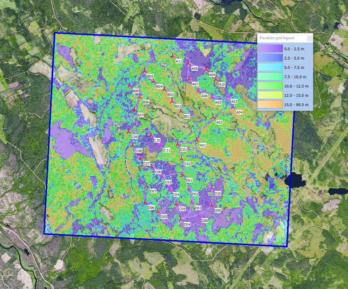
- 13:1813:18, 14 June 2018 diff hist 0 File:ExampleGSDSweden.png Morten uploaded a new version of "File:ExampleGSDSweden.png" current
- 12:0412:04, 14 June 2018 diff hist 0 N File:ExampleGSDSweden.png No edit summary
- 12:0212:02, 14 June 2018 diff hist +92 Swedish Elevation Model No edit summary
5 April 2018
- 01:5701:57, 5 April 2018 diff hist 0 N File:SwedishWindFarm CopernicusVHR.png No edit summary current
- 01:5601:56, 5 April 2018 diff hist +19 WindPRO European Satellite Imagery No edit summary
- 01:4801:48, 5 April 2018 diff hist −6 WindPRO European Satellite Imagery →Dataset Description
- 01:4801:48, 5 April 2018 diff hist −1,004 WindPRO European Satellite Imagery No edit summary
- 01:3601:36, 5 April 2018 diff hist +3,503 N WindPRO European Satellite Imagery Created page with "Category:Online DataCategory:Maps right|thumb|400px|Site: Østerild National Test Site, Denmark == Introduction == Image:Sentinel2Spa..."
- 01:3001:30, 5 April 2018 diff hist 0 Copernicus Global Land Service - Land Cover 100m →Validation