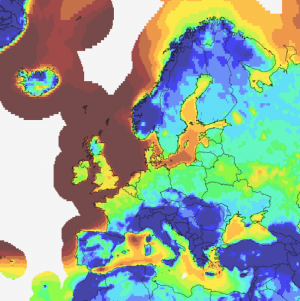
ERA5(T) Rectangular Grid

Introduction
ERA5/5T (Geographic Grid) provides the most up-to date ERA5 data - including the ERA5T data. It is a part of the ERA5 data offerings in windPRO - now with two datasets on two different grids - geographical and gaussian. Both datasets hold a focused parameter-subset of the ERA5 and ERA5T data - each dating back more than 20 years. This ERA5/5T (Geographic Grid) data provides both ERA5 and ERA5T (preliminary data for ERA5) on a daily or weekly basis, with the most recent data being available with about a 5-day delay from real time.
Why an additional ERA5 (Geographic Grid) dataset in windPRO? The first ERA5-windPRO ERA5 (Gaussian Grid) data . initial ERA5 windPRO dataset released in 2017 is based on the raw ERA5 data on a reduced gaussian grid. Unfortuantely the newly released ERA5T (updated with a shorter delay) data is not available on the reduced gaussian grid, but only on the 0.25x0.25 grid available in the Climate Data Store. In order to have a dataset in windPRO with ERA5T data this ERA5 CDS Grid dataset is made available.
For a general introduction to the ERA5 data, please refer to our ERA5 (Gaussian Grid) wiki-page.
Resolution and Coverage
Resolution:
The dataset grid is an interpolated regular lat/lon grid at 0.25x0.25 resolution (around 27.8 km). It holds hourly values. Coverage is global for land-areas and coastal regions. In windPRO, offshore coverage is expected to cover an area of approximately 300 km from the coastline.
Update plan
The dataset holds data back to 1999 and will be updated with new data twice a month with a one week delay. The first update will be around the 8th of a month where all data from the previous month will be available. The second update will be around the 23rd of a month where the first half of the month will be available.
Once the final ERA5 data becomes available (after 2-3 months) the dataset will be updated with that data. According to ECMWF they do not expect changes to happen very often and in the event that it does happen it will be communicated to users. At EMD we will communicate any such changes to the windPRO users as well.
Data Parameters
EMD extracts a focused subset of climate-parameters from the ERA5 datasets - this subset focuses on wind-energy modelling. When the data have been processed at EMD, then the following parameters are available from within the online-data services within windPRO.
| Parameter | Unit | Description |
|---|---|---|
| time | UTC time stamp | |
| wSpeed.10 | m/s | Wind speed @ 10m |
| wDir.10 | deg | Wind direction @ 10m |
| wSpeed.100 | m/s | Wind speed @ 100m |
| wDir.100 | deg | Wind direction @ 100m |
| temperature.2 | deg.celcius | Temperature @ 2m |
| dewPointTemp.2 | deg.celcius | Dew point temperature @ 2m |
| rh.2 | % | Relative humidity @ 2m |
| psfc | pa | Surface pressure |
| msl | pa | Mean sea-level pressure |
| blh | m | Boundary layer height |
| tcc | % | Total cloud cover |
| heatFlux | w/m2 | Instantaneous surface sensible heat flux |
| zust | m/s | Friction velocity |
| cbh | m | Cloud base height |
| ssrdAcc | w/m2 | Surface solar radiation downwards |
| era5t | 0/1 | Binary variable indicating whether the sample is ERA5T data |
Required Modules/Licenses
To access the ERA5 reanalysis data from within windPRO - the following licenses/modules are required in your windPRO setup:
- Basis
- METEO
When the license fee is paid, you then have access to the full dataset without further cost. Downloading of data is unrestricted for licenced users, however, a "fair use" policy applies. Visit EMD online ordering to purchase the needed licences.
Attribution
If data from this dataset is used within any private or public disseminations, then EMD and its data providers must be acknowledged.
Source:
ERA5 (Geographic Grid). Distribution through EMD and windPRO - EMD International A/S, 2020.
This dataset uses ERA5 which is being developed through the Copernicus Climate Change Service (C3S).
Data processing and distribution for ERA5 is carried out by ECMWF.
External Links
- ECMWF - What is ERA5 - https://software.ecmwf.int/wiki/display/CKB/What+is+ERA5
- ERA5 Data Documentation at ECMWF - https://software.ecmwf.int/wiki/display/CKB/ERA5+data+documentation
- Copernicus Climate Change Service - ERA5 Page - https://climate.copernicus.eu/products/climate-reanalysis