Difference between revisions of "Austrian Elevation Model"
Jump to navigation
Jump to search
(Created page with "This page will hold the description of the Austrian Elevation model.") |
|||
| (9 intermediate revisions by 3 users not shown) | |||
| Line 1: | Line 1: | ||
| − | + | [[Category: Online Data]][[Category: Digital Elevation Models]][[Category: InnoWind]] | |
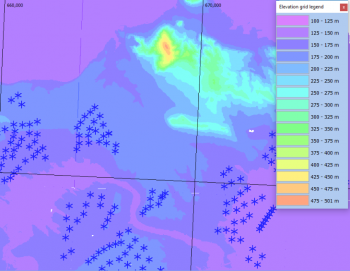
| + | [[Image:AUT10.png|right|thumb|350px|Austrian DEM. Image showing part of the 100+ turbine cluster SE of Vienna.]] | ||
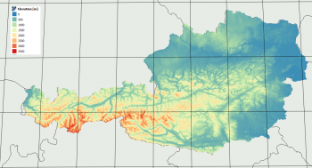
| + | [[Image:AUT10Coverage.png|right|thumb|350px|Coverage of the Austrian DTM.]] | ||
| + | == Introduction == | ||
| + | The Austrian elevation model is a digital terrain model (Digitales Geländemodell) produced by the geoland project – a joint effort and portal from the nine provinces of Austria. The Austrian DTM model was built from airborne laserscans. | ||
| + | |||
| + | === Dataset Overview === | ||
| + | * '''Spatial Coverage:''' Austria | ||
| + | * '''Resolution:''' 10 m | ||
| + | * '''Data-type:''' [[:Category%3ADigital_Elevation_Models#What_type_of_elevation_model.3F_DEM.2C_DSM_and_DTM.3F|Digital Terrain Model (DTM)]] | ||
| + | * '''Coordinate system:''' Austrian Lambert (EPSG 31287) in original data | ||
| + | * '''Version:''' Data downloaded in January 2019. | ||
| + | * '''Vertical Accuracy:''' N/A | ||
| + | |||
| + | == Availability from within WindPRO == | ||
| + | The data are available directly from within windPRO in 10-meter resolution. The data can be accessed from the online-services in the following objects: | ||
| + | * Line Object (with purpose to height contour lines) | ||
| + | * Elevation Grid Object | ||
| + | |||
| + | == License and Attribution == | ||
| + | The product belongs to the open geo-data of Austria (Offene Daten Österreich). The data have been licensed under a [https://creativecommons.org/licenses/by/3.0/at/deed.en Creative Commons Attribution 3.0 Austria] License (CC BY 3.0 AT). | ||
| + | |||
| + | Please accept the license conditions and use a proper attribution when using this dataset, such as: <br> | ||
| + | <pre> | ||
| + | Contains Austrian elevation data from the Geoland Project (geoland.at). | ||
| + | Distribution through EMD and windPRO. CC BY 3.0 AT geoland.at. | ||
| + | </pre> | ||
| + | |||
| + | == Acknowledgement == | ||
| + | * The Geoland project and the Austrian provinces are thanked for producing this digital elevation dataset – and disseminating it in the public domain and thus for aiding the development of renewable energy. | ||
| + | * Integration of this dataset into EMD services was co-supported through the InnoWind project (www.innowind.dk) which is co-funded by the Danish Innovation Fund | ||
| + | |||
| + | == External Links == | ||
| + | # Description of the elevation model - Austrian Data Catalogue - [https://www.data.gv.at/katalog/dataset/d88a1246-9684-480b-a480-ff63286b35b7 HERE] | ||
| + | # InnoWind project: http://www.innowind.dk | ||
Latest revision as of 08:49, 15 April 2020
Introduction
The Austrian elevation model is a digital terrain model (Digitales Geländemodell) produced by the geoland project – a joint effort and portal from the nine provinces of Austria. The Austrian DTM model was built from airborne laserscans.
Dataset Overview
- Spatial Coverage: Austria
- Resolution: 10 m
- Data-type: Digital Terrain Model (DTM)
- Coordinate system: Austrian Lambert (EPSG 31287) in original data
- Version: Data downloaded in January 2019.
- Vertical Accuracy: N/A
Availability from within WindPRO
The data are available directly from within windPRO in 10-meter resolution. The data can be accessed from the online-services in the following objects:
- Line Object (with purpose to height contour lines)
- Elevation Grid Object
License and Attribution
The product belongs to the open geo-data of Austria (Offene Daten Österreich). The data have been licensed under a Creative Commons Attribution 3.0 Austria License (CC BY 3.0 AT).
Please accept the license conditions and use a proper attribution when using this dataset, such as:
Contains Austrian elevation data from the Geoland Project (geoland.at).
Distribution through EMD and windPRO. CC BY 3.0 AT geoland.at.
Acknowledgement
- The Geoland project and the Austrian provinces are thanked for producing this digital elevation dataset – and disseminating it in the public domain and thus for aiding the development of renewable energy.
- Integration of this dataset into EMD services was co-supported through the InnoWind project (www.innowind.dk) which is co-funded by the Danish Innovation Fund
External Links
- Description of the elevation model - Austrian Data Catalogue - HERE
- InnoWind project: http://www.innowind.dk

