Difference between revisions of "Danish Bathymetry"
| Line 29: | Line 29: | ||
== Acknowledgement == | == Acknowledgement == | ||
| − | * The | + | * The Danish Geodata Agency is thanked for producing this digital bathymetry dataset – and disseminating it in the public domain and thus for aiding the development of renewable energy. |
| − | |||
== External Links == | == External Links == | ||
# Description of the EMODnet Bathymetry data set: http://www.emodnet-bathymetry.eu/data-products | # Description of the EMODnet Bathymetry data set: http://www.emodnet-bathymetry.eu/data-products | ||
# InnoWind project: http://www.innowind.dk | # InnoWind project: http://www.innowind.dk | ||
Revision as of 19:15, 2 January 2023
NOTE 2023-01-02: This dataset is currenly being integrated into windPRO. It will be available in windPRO shortly.
Introduction
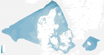
"Denmark's Depth Model (2022)' is now available for windPRO users working with offshore wind farm development within the Danish EEZ. The model has a grid resolution of 50 meters and is based on a collection of hydrographic survey datasets and hirsorical sources. Model coverage is Denmark's Exclusive Economic Zone (EEZ). The model is developed and released by the Danish Geodata Agency and reflect the data-status as of year 2022.
Availability from within WindPRO and Usage Notes
The data is available directly from within windPRO and can be accessed from the online-services in the Elevation Grid Object.
Usage:
- In order to access the data, please set the purpose of the Elevation Grid Object to 'Water depths'.
- If you want to export the grid to contour lines: This can be done from within the grid-object, simply select the layer of interest, then choose 'Export Layer'.
Reference System
The following reference systems were used in the original data:
- Horizontal:
Lambert Conformal Conic (LCC) / ETRS89 (EPSG:3034) - Vertical:
A combination of Mean Low Water Spring (MLWS), Lowest Astronomical Tide (LAT) and Dansk Vertikal Reference 1990 (DVR90)
Coverage
- Denmark's Exclusive Economic Zone (EEZ) - see the map to the right
License and Attribution
As a part of the license conditions, users are requested to provide a reference to the Danish Geodata Agency. Also note, that it is not allowed to use the dataset for navigation purposes. Please use the following (or a similar) attribution when using this dataset - and also accept the terms of use (pdf) from from the Danish Geodata Agency.
Data Source:
Denmark's Depth Model, 50 m resolution. Contains data from the Danish Geodata Agency.
Contains data from Denmark's Depth Model, 50 m resolution from the Danish Geodata Agency, November 2022.
Danish Geodata Agency – (Data may not be used for navigation). Distribution through windPRO and EMD.
Acknowledgement
- The Danish Geodata Agency is thanked for producing this digital bathymetry dataset – and disseminating it in the public domain and thus for aiding the development of renewable energy.
External Links
- Description of the EMODnet Bathymetry data set: http://www.emodnet-bathymetry.eu/data-products
- InnoWind project: http://www.innowind.dk
