Difference between revisions of "OSM Turbines"
Jump to navigation
Jump to search
| Line 1: | Line 1: | ||
[[Category:Online_Data]][[Category:Existing_Turbines]] | [[Category:Online_Data]][[Category:Existing_Turbines]] | ||
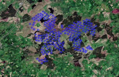
| − | [[File:WhiteleeWF_50pct.png|right|thumb|Whitelee Wind Farm with wind tubine data from OSM]]WindPRO contains a database with existing turbines derived from the [https://www.openstreetmap.org Open Street Map project]. | + | [[File:WhiteleeWF_50pct.png|right|thumb|400px|Whitelee Wind Farm with wind tubine data from OSM]]WindPRO contains a database with existing turbines derived from the [https://www.openstreetmap.org Open Street Map project]. The dataset is not complete as it is added by volunteer contributors. The data set only contains the position for the turbines - but may be helpful in identifying nearby turbines. |
| − | The dataset is not complete as it is added by volunteer contributors. The data set only contains the position for the turbines - but may be helpful in identifying nearby turbines. | ||
This dataset is updated typically once a year. | This dataset is updated typically once a year. | ||
| Line 7: | Line 6: | ||
== License== | == License== | ||
OpenStreepMap data is open data, which can be used freely as long as OpenStreetMap and it contributors are credited. | OpenStreepMap data is open data, which can be used freely as long as OpenStreetMap and it contributors are credited. | ||
| + | The OSM license FAQ deals with may of the license question: http://wiki.openstreetmap.org/wiki/Legal_FAQ | ||
== External Links == | == External Links == | ||
* Homepage for the Open Street Map project: https://www.openstreepmap.org | * Homepage for the Open Street Map project: https://www.openstreepmap.org | ||
* Homepage for the Open Street Map foundation: https://wiki.osmfoundation.org/wiki/Main_Page | * Homepage for the Open Street Map foundation: https://wiki.osmfoundation.org/wiki/Main_Page | ||
| − | |||
Revision as of 12:19, 6 October 2017
WindPRO contains a database with existing turbines derived from the Open Street Map project. The dataset is not complete as it is added by volunteer contributors. The data set only contains the position for the turbines - but may be helpful in identifying nearby turbines.
This dataset is updated typically once a year.
License
OpenStreepMap data is open data, which can be used freely as long as OpenStreetMap and it contributors are credited. The OSM license FAQ deals with may of the license question: http://wiki.openstreetmap.org/wiki/Legal_FAQ
External Links
- Homepage for the Open Street Map project: https://www.openstreepmap.org
- Homepage for the Open Street Map foundation: https://wiki.osmfoundation.org/wiki/Main_Page
