NORA3: Difference between revisions
m (→Usage Notes) |
|||
| (30 intermediate revisions by 3 users not shown) | |||
| Line 1: | Line 1: | ||
[[Category:Online Data]][[Category:Wind Data]][[Category: Atlas Data]] | |||
[[Category:Online Data]][[Category:Wind Data]] | [[File:NORA3_DomainInWindPRO.png|right|thumb|450px|Spatial domain for the NORA3 mesoscale data in windPRO (we cover approx. 300km from the coastline). Image showing average wind speeds from 2004-2021 - taken from the https://www.windprospecting.com platform.]] | ||
[[ | |||
[[File:NORA3_FullDomain.png|right|thumb|450px|Full domain for the NORA3 hindcast data. Image showing temperature in degrees Kelvin on 2021-12-31.]] | [[File:NORA3_FullDomain.png|right|thumb|450px|Full domain for the NORA3 hindcast data. Image showing temperature in degrees Kelvin on 2021-12-31.]] | ||
==Introduction== | ==Introduction== | ||
The Norwegian Reanalysis, NORA3, is a high resolution hindcast dataset provided by the Norwegian Meteorological Institute. The model holds data at 3km resolution and covers significant on- and offshore areas around the Baltic Sea, North Sea, the Norwegian Sea and the Barents Sea. NORA3 is downscaling to the 3km resolution with initial conditions and boundary conditions provided from [[ERA5_Gaussian_Grid|ERA5 reanalysis data]]. However, | The Norwegian Reanalysis, NORA3, is a high resolution hindcast dataset provided by the Norwegian Meteorological Institute. The model holds data at 3km resolution and covers significant on- and offshore areas around the Baltic Sea, North Sea, the Norwegian Sea and the Barents Sea. NORA3 is downscaling to the 3km resolution with initial conditions and boundary conditions provided from [[ERA5_Gaussian_Grid|ERA5 reanalysis data]]. However, a surface analysis is also made in order to further refine initial condition at each integration cycle. This is done by assimilating meteorological data from SYNOP and METAR stations, ships and buoys from the MARS database. While some of the mesoscale datasets used in wind energy industry are calculated using the excellent WRF model, here the numerical weather prediction model used is HARMONIE–AROME in its release "Cy 40h1.2". As such, the NORA3 dataset provides a welcome and alternative modelling chain to what is commonly used for wind-energy modelling - providing valuable input for uncertainty modelling and second-opinion analyses. The HARMONIE-AROME model is developed and used by many European meteorological institutes. | ||
===Dataset Overview=== | ===Dataset Overview=== | ||
* '''Content:''' Limited feature and | * '''Content:''' Limited feature and spatial-domain subset of the NORA3 mesoscale dataset <br>(we provide about 760.000 nodes in a distance of approx. 300km from the coastlines). | ||
* '''Spatial resolution:''' 3km | * '''Spatial resolution:''' 3km | ||
* '''Temporal resolution:''' Timestep 1 hour | * '''Temporal resolution:''' Timestep 1 hour | ||
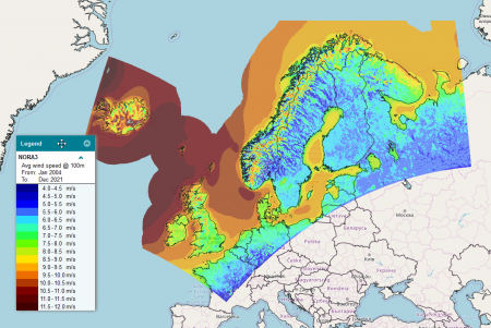
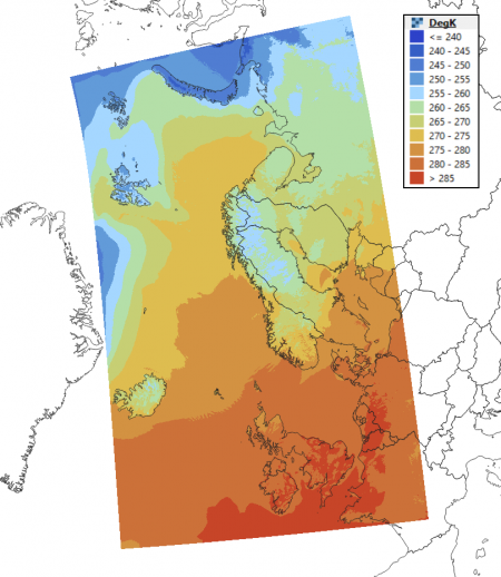
* '''Coverage:''' See the map to the right | * '''Coverage:''' See the map to the right | ||
* '''Period:''' In windPRO: 20+ years of data from 1999-01-01 to 2021-12-31<br>(back to 1984 from Norwegian Meteorological Institute) | * '''Period:''' In windPRO: 20+ years of data from 1999-01-01 to 2021-12-31<br>(source data dates back to 1984 from Norwegian Meteorological Institute) | ||
* '''Update schedule:''' Unknown.<br>We will update this dataset when | * '''Update schedule:''' Unknown (but is is our expectation that data is updated with a 3-4 month of delay from current date, due to ERA5 availability and computational demands).<br>We will update this dataset when more recent data becomes available from the Norwegian Meteorological Institute.<br> | ||
== Availability as Atlas-Data == | |||
[[Image:NORA3_Atlas.png|right|thumb|450px|NORA3 Atlas Data - At Anholt Offshore Wind Farm and [[EMD_Electrical_Grid_Map|EMD Electrical Grid Map]] as Background Map]][[Image:NORA3_Atlas_Weibull_100m.png|right|thumb|450px|Weibull A at 100m for NORA3 Domain in windPRO]] | |||
The NORA3 dataset is also available as [[:Category%3AAtlas_Data|atlas data]] through [https://www.emd-international.com/windpro/ windPRO] and [https://api.emd.dk/ EMD-API]. The atlas-data is provided in the standard [https://www.emd.dk/files/flow/EMD_technote_SITERES_20170515.pdf .siteres] format and can be used directly as analysis-ready-data (ARD) in windPRO within many modules: PARK, Site Compliance/Load Response and Optimization calculations. The atlas is pre-generated for a 10-year period (2008-2017). This is the same years as for the global [[GASP_Global|EMD-GASP]] dataset. | |||
'''DISCLAIMER:''' | |||
''The atlas-statistics have been calculated directly from the mesoscale-time-series data, suitable for offshore or 'simple' terrain locations. Special care should be taken when using these data for sites with significant microscale effects due to strong local orographic or roughness variations. In those cases, it is highly recommended to downscale the time-series directly using the [https://help.emd.dk/knowledgebase/content/windPRO4.0/c3-UK_windPRO4.0_ENERGY.html#pf1a windPRO downscaling feature] or using the [[GASP_Global|GASP]] dataset as an alternative. We also recommend to validate or adjust/calibrate the model using local ground-truth data, such as data from a meteorological mast or production data from wind turbines within the area of interest.'' | |||
The NORA3 [https://www.emd.dk/files/flow/EMD_technote_SITERES_20170515.pdf .siteres]-file holds the following parameters: | |||
* Elevation (mesoscale-terrain) | |||
* Air Density (heights: 10m, 20m, 50m, 100m, 250m, 500m)<br>(Calculated from temperature at 2m, pressure at 2m and meso-elevation using the standard-atmosphere model) | |||
* Weibull: Omni-directional as well as 12 sectors (heights: 10m, 20m, 50m, 100m, 250m, 500m)<br>(A, k, sector-frequency) | |||
The atlas-data are distributed using a geographical coordinate-system (EPSG:4326). The resampling and coordinate-transformation is done automatically, using a nearest-neighbour approach and preserving a 3km spatial resolution in the centre-cell of the atlas (approx. 100 arc-second, 3km resolution). | |||
==Usage Notes== | ==Usage Notes== | ||
# '''I am interested in other parameters and other areas. Where can I get those?''' The data is freely available from the thredds server at the Norwegian Meteorological Institute (https://thredds.met.no/thredds/catalog.html). | # '''I am interested in other parameters and other areas. Where can I get those?''' The data is freely available from the thredds server at the Norwegian Meteorological Institute (https://thredds.met.no/thredds/catalog.html). | ||
# '''How can I get turbulence intensities from the NORA3 data?''' This parameter is not available - but it may be possible to come up with an estimate by using the gust-value provided (we have not tried this - yet). | # '''How can I get turbulence intensities from the NORA3 data?''' This parameter is not available - but it may be possible to come up with an estimate by using the gust-value provided (we have not tried this - yet). | ||
# '''I am already using EMD-WRF Europe+ wind speed data. How does NORA3 perform in comparison?''' | # '''I am already using EMD-WRF Europe+ wind speed data. How does NORA3 perform in comparison?''' An evaluation memo is available - comparing modelling-data from NORA3, [[New_European_Wind_Atlas_(NEWA)|NEWA]], [[EMD-WRF_Europe%2B|EMD-WRF EUR+]] and [[ERA5_Gaussian_Grid|ERA5]] with 74 high-quality and tall masts - access the validation-one-pager [https://help.emd.dk/mediawiki/images/5/5d/20220505_AccuracyNORA3WindSpeeds.pdf here]. | ||
# '''How do I find more on model details and model performance?''' See the external references below. Comprehensive model documentation and validation on offshore wind data is available. | |||
# '''How do I find more on model details and model performance | |||
==Dataset Parameters== | ==Dataset Parameters== | ||
| Line 81: | Line 91: | ||
==License and Attribution== | ==License and Attribution== | ||
This dataset is a subset of the NORA3 mesoscale dataset | This dataset is a subset of the NORA3 mesoscale dataset. The full NORA3 dataset is freely available from the Norwegian Meteorological Institute. It has been released under the Norwegian License for Open Government Data (NLOD) 2.0 and the Creative Commons By Attribution 4.0 license (CC-BY-40) - https://data.norge.no/nlod/en/2.0/ and https://creativecommons.org/licenses/by/4.0/. As a part of the license conditions, the data-owner requires an attribution, such as: | ||
<pre> | <pre> | ||
Source: | Source: | ||
NORA3 data obtained from the Norwegian Meteorological Institute. | NORA3 data obtained from the Norwegian Meteorological Institute. | ||
Distribution through EMD and windPRO - EMD International A/S, | Distribution through EMD and windPRO - EMD International A/S, 2022. License: NLOD 2.0 and CC-BY-40. | ||
</pre> | </pre> | ||
| Line 95: | Line 105: | ||
== External Links and References== | == External Links and References== | ||
* Norwegian Meteorological Institute - [https://www.met.no/en here ] | * Norwegian Meteorological Institute - the creator of the NORA3 data - [https://www.met.no/en here ] | ||
* NORA3 - thredds server at the Norwegian Meteorological | * NORA3 - thredds server at the Norwegian Meteorological Institute - [https://thredds.met.no/thredds/catalog.html here ] | ||
* NORA3 Model Description Publication by Haakenstad et al | * NORA3 Model Description Publication by Haakenstad et al - in Journal of Applied Meteorology and Climatology - [https://doi.org/10.1175/JAMC-D-21-0029.1 here] | ||
* NORA3 Validation Paper by Solbrekke, Sorteberg & Haakenstad - in Wind Energy Science - [https://help.emd.dk/mediawiki/images/a/a5/Solbrekke_3kmNorwegianReanalysisNORA3_Validation.pdf here] | * NORA3 Validation Paper by Solbrekke, Sorteberg & Haakenstad - in Wind Energy Science - [https://help.emd.dk/mediawiki/images/a/a5/Solbrekke_3kmNorwegianReanalysisNORA3_Validation.pdf here] | ||
==Acknowledgement and Credits== | ==Acknowledgement and Credits== | ||
# Credits and Acknowledgement: The Norwegian Meteorological Institute and the Norwegian public for the release of the NORA3 hindcast dataset as a free and open dataset. | # Credits and Acknowledgement: The Norwegian Meteorological Institute and the Norwegian public for the release of the NORA3 hindcast dataset as a free and open dataset. | ||
Latest revision as of 11:35, 5 December 2024


Introduction
The Norwegian Reanalysis, NORA3, is a high resolution hindcast dataset provided by the Norwegian Meteorological Institute. The model holds data at 3km resolution and covers significant on- and offshore areas around the Baltic Sea, North Sea, the Norwegian Sea and the Barents Sea. NORA3 is downscaling to the 3km resolution with initial conditions and boundary conditions provided from ERA5 reanalysis data. However, a surface analysis is also made in order to further refine initial condition at each integration cycle. This is done by assimilating meteorological data from SYNOP and METAR stations, ships and buoys from the MARS database. While some of the mesoscale datasets used in wind energy industry are calculated using the excellent WRF model, here the numerical weather prediction model used is HARMONIE–AROME in its release "Cy 40h1.2". As such, the NORA3 dataset provides a welcome and alternative modelling chain to what is commonly used for wind-energy modelling - providing valuable input for uncertainty modelling and second-opinion analyses. The HARMONIE-AROME model is developed and used by many European meteorological institutes.
Dataset Overview
- Content: Limited feature and spatial-domain subset of the NORA3 mesoscale dataset
(we provide about 760.000 nodes in a distance of approx. 300km from the coastlines). - Spatial resolution: 3km
- Temporal resolution: Timestep 1 hour
- Coverage: See the map to the right
- Period: In windPRO: 20+ years of data from 1999-01-01 to 2021-12-31
(source data dates back to 1984 from Norwegian Meteorological Institute) - Update schedule: Unknown (but is is our expectation that data is updated with a 3-4 month of delay from current date, due to ERA5 availability and computational demands).
We will update this dataset when more recent data becomes available from the Norwegian Meteorological Institute.
Availability as Atlas-Data


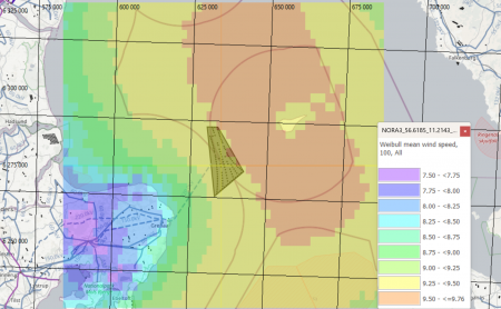
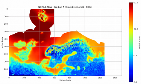
The NORA3 dataset is also available as atlas data through windPRO and EMD-API. The atlas-data is provided in the standard .siteres format and can be used directly as analysis-ready-data (ARD) in windPRO within many modules: PARK, Site Compliance/Load Response and Optimization calculations. The atlas is pre-generated for a 10-year period (2008-2017). This is the same years as for the global EMD-GASP dataset.
DISCLAIMER: The atlas-statistics have been calculated directly from the mesoscale-time-series data, suitable for offshore or 'simple' terrain locations. Special care should be taken when using these data for sites with significant microscale effects due to strong local orographic or roughness variations. In those cases, it is highly recommended to downscale the time-series directly using the windPRO downscaling feature or using the GASP dataset as an alternative. We also recommend to validate or adjust/calibrate the model using local ground-truth data, such as data from a meteorological mast or production data from wind turbines within the area of interest.
The NORA3 .siteres-file holds the following parameters:
- Elevation (mesoscale-terrain)
- Air Density (heights: 10m, 20m, 50m, 100m, 250m, 500m)
(Calculated from temperature at 2m, pressure at 2m and meso-elevation using the standard-atmosphere model) - Weibull: Omni-directional as well as 12 sectors (heights: 10m, 20m, 50m, 100m, 250m, 500m)
(A, k, sector-frequency)
The atlas-data are distributed using a geographical coordinate-system (EPSG:4326). The resampling and coordinate-transformation is done automatically, using a nearest-neighbour approach and preserving a 3km spatial resolution in the centre-cell of the atlas (approx. 100 arc-second, 3km resolution).
Usage Notes
- I am interested in other parameters and other areas. Where can I get those? The data is freely available from the thredds server at the Norwegian Meteorological Institute (https://thredds.met.no/thredds/catalog.html).
- How can I get turbulence intensities from the NORA3 data? This parameter is not available - but it may be possible to come up with an estimate by using the gust-value provided (we have not tried this - yet).
- I am already using EMD-WRF Europe+ wind speed data. How does NORA3 perform in comparison? An evaluation memo is available - comparing modelling-data from NORA3, NEWA, EMD-WRF EUR+ and ERA5 with 74 high-quality and tall masts - access the validation-one-pager here.
- How do I find more on model details and model performance? See the external references below. Comprehensive model documentation and validation on offshore wind data is available.
Dataset Parameters
A total of 21 parameters are available from the NORA3 mesoscale data-subset in windPRO. Wind speeds and directions are available in 6 heights from 10m to 500m agl.
| Parameter(s) | Description | Unit |
|---|---|---|
| time | UTC time stamp | YYYY-MM-DD HH:MM |
| temp.2m | Temperature in 2m height | degC |
| rh.2m | Relative humidity in 2m height | % |
| press.2m | Surface air pressure | Pa |
| gust.10m | Wind gust (maximum wind) in 10m agl | m/s |
| ws.10m, ws.20m, ws.50m, ws.100m, ws.250m, ws.500m | Wind speed in 10m, 20m, 50m, 100m, 250m and 500m agl | m/s |
| wdir.10m, wdir.20m, wdir.50m, wdir.100m, wdir.250m, wdir.500m | Wind direction in 10m, 20m, 50m, 100m, 250m and 500m agl | deg |
| precipAcc | Accumulated total precipitation | kg/m2/h |
| snowAcc | Total accumulated solid precipitation (snow+graupel+hail) | kg/m2/h |
| lwcss | Snow Water Equivivalent (SWE) | kg/m2/h |
| PBL | Planetary boundary layer height | m |
License and Attribution
This dataset is a subset of the NORA3 mesoscale dataset. The full NORA3 dataset is freely available from the Norwegian Meteorological Institute. It has been released under the Norwegian License for Open Government Data (NLOD) 2.0 and the Creative Commons By Attribution 4.0 license (CC-BY-40) - https://data.norge.no/nlod/en/2.0/ and https://creativecommons.org/licenses/by/4.0/. As a part of the license conditions, the data-owner requires an attribution, such as:
Source:
NORA3 data obtained from the Norwegian Meteorological Institute.
Distribution through EMD and windPRO - EMD International A/S, 2022. License: NLOD 2.0 and CC-BY-40.
Required windPRO License and Modules
This dataset can be accessed from the most recent version of windPRO given that you hold an active service agreement and a license to the following modules:
- BASIS
- METEO
External Links and References
- Norwegian Meteorological Institute - the creator of the NORA3 data - here
- NORA3 - thredds server at the Norwegian Meteorological Institute - here
- NORA3 Model Description Publication by Haakenstad et al - in Journal of Applied Meteorology and Climatology - here
- NORA3 Validation Paper by Solbrekke, Sorteberg & Haakenstad - in Wind Energy Science - here
Acknowledgement and Credits
- Credits and Acknowledgement: The Norwegian Meteorological Institute and the Norwegian public for the release of the NORA3 hindcast dataset as a free and open dataset.