US Wind Turbines: Difference between revisions
mNo edit summary |
|||
| (32 intermediate revisions by 2 users not shown) | |||
| Line 1: | Line 1: | ||
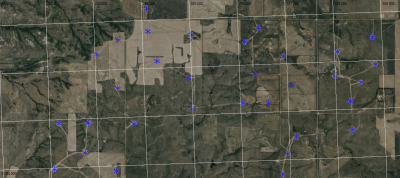
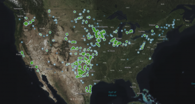
[[Category:Online_Data]][[Category:Existing_Turbines]] | [[Category:Online_Data]][[Category:Existing_Turbines]][[Image:USWTDB_50km_West_of_Bismarck_NorthDakota_US.png|right|thumb|400px|USWTDB at work, 50km to the west of Bismarck, North Dakota, USA]][[Image:Usgs_wind_farm_coverage_2020_09.png|right|thumb|400px|Coverage of USWTDB.]] | ||
== Introduction == | == Introduction == | ||
A database of existing wind turbines in the United States is available for import in windPRO | A database of existing wind turbines in the United States is available for import in windPRO. The database has been published by the U.S. Geological Survey (http://usgs.gov) and consists of 74.511 wind turbines as of May 2024. Turbine positions have been verified by U.S. Geological Survey using visual interpretation of high-resolution aerial imagery. The database was started back in 2016, where USGS, LBNL, and the American Wind Energy Association (AWEA, the predecessor of ACP) began collaborating on development of the USWTDB. | ||
== | === About the USWTDB in windPRO === | ||
The database | The majority of the wind turbines (50.12%) in the USWTDB database have been mapped to wind turbines in the [[WTG_Catalogue|windPRO WTG catalogue]] and as such the imported WTG object will have the correct type, rated power, hub height and rotor diameter. When metadata object-information is available from USWTDB, then it is added to the WTG Objects description tab, this includes, for example, source unique identifiers, attribute and location confidence, image source used for validation, project name and location (state and county). | ||
In situations where the imported WTG type is unknown (or cannot be mapped from the windPRO WTG catalogue), the WTG object will still be created in the correct position and the description of the object will be: | |||
<pre> | |||
Not found: <Manufacturer> <Rated Power> <Rotor diameter> <Hub height> | |||
</pre> | |||
(Depending on the availability of additional information about this particular wind turbine) | |||
== | == Coverage == | ||
The | The database existing land-based wind turbines within the United States og America. Note that offshore wind farms are not included. <br> | ||
See [https://eerscmap.usgs.gov/uswtdb/viewer/#3/37.25/-96.25 https://eerscmap.usgs.gov/uswtdb/viewer/#3/37.25/-96.25] for an the interactive map displaying coverage. | |||
== History (versions) in windPRO == | |||
* 2024-06-27 - Updated to version USWTDB_V7_0_20240510 | |||
* 2020-09-06 - Update of USWTDB added to windPRO | |||
* 2015-03-05 - First edition added to windpro (USWTDB version from july 2013) | |||
== License and Attribution == | |||
USWTDB data are free and in the public domain. There are no restrictions; however, the authors request that the following acknowledgment statement be included in products and data derived from our map services when citing, copying, or reprinting: | |||
<pre>USWTDB Data-Source: | |||
Map services and data are available from U.S. Wind Turbine Database, provided by the U.S. Geological Survey, American Clean Power Association, and Lawrence Berkeley National Laboratory via https://eerscmap.usgs.gov/uswtdb.</pre> | |||
== Suggested Citations == | |||
The suggested citation for use in academic papers and otherwise where applicable is as follows: | |||
== | * ''2024-version:'' Hoen, B.D., Diffendorfer, J.E., Rand, J.T., Kramer, L.A., Garrity, C.P., and Hunt, H.E., 2018, United States Wind Turbine Database v7.0 (May 10, 2024): U.S. Geological Survey, American Clean Power Association, and Lawrence Berkeley National Laboratory data release, https://doi.org/10.5066/F7TX3DN0. | ||
Diffendorfer, J.E., Compton, Roger, Kramer, Louisa, Ancona, Zach, and Norton, Donna, 2014, Onshore industrial wind turbine locations for the United States through July 2013: U.S. Geological Survey Data Series 817, http://dx.doi.org/10.3133/ds817. | * ''2020-version:'' Diffendorfer, J.E., Compton, Roger, Kramer, Louisa, Ancona, Zach, and Norton, Donna, 2014, Onshore industrial wind turbine locations for the United States through July 2013: U.S. Geological Survey Data Series 817, http://dx.doi.org/10.3133/ds817. ISSN 2327-638x (online) | ||
ISSN 2327-638x (online) | |||
== External Links == | == External Links == | ||
Interactive map | * Interactive map from USGS - [https://eerscmap.usgs.gov/uswtdb/viewer/#3/37.25/-96.25/ here] | ||
* USWTDB data source from USGS - [https://eerscmap.usgs.gov/uswtdb/ here] | |||
Additional information | * Additional information on USWTDB - [http://pubs.usgs.gov/ds/817/ here] | ||
Latest revision as of 21:38, 27 June 2024


Introduction
A database of existing wind turbines in the United States is available for import in windPRO. The database has been published by the U.S. Geological Survey (http://usgs.gov) and consists of 74.511 wind turbines as of May 2024. Turbine positions have been verified by U.S. Geological Survey using visual interpretation of high-resolution aerial imagery. The database was started back in 2016, where USGS, LBNL, and the American Wind Energy Association (AWEA, the predecessor of ACP) began collaborating on development of the USWTDB.
About the USWTDB in windPRO
The majority of the wind turbines (50.12%) in the USWTDB database have been mapped to wind turbines in the windPRO WTG catalogue and as such the imported WTG object will have the correct type, rated power, hub height and rotor diameter. When metadata object-information is available from USWTDB, then it is added to the WTG Objects description tab, this includes, for example, source unique identifiers, attribute and location confidence, image source used for validation, project name and location (state and county).
In situations where the imported WTG type is unknown (or cannot be mapped from the windPRO WTG catalogue), the WTG object will still be created in the correct position and the description of the object will be:
Not found: <Manufacturer> <Rated Power> <Rotor diameter> <Hub height>
(Depending on the availability of additional information about this particular wind turbine)
Coverage
The database existing land-based wind turbines within the United States og America. Note that offshore wind farms are not included.
See https://eerscmap.usgs.gov/uswtdb/viewer/#3/37.25/-96.25 for an the interactive map displaying coverage.
History (versions) in windPRO
- 2024-06-27 - Updated to version USWTDB_V7_0_20240510
- 2020-09-06 - Update of USWTDB added to windPRO
- 2015-03-05 - First edition added to windpro (USWTDB version from july 2013)
License and Attribution
USWTDB data are free and in the public domain. There are no restrictions; however, the authors request that the following acknowledgment statement be included in products and data derived from our map services when citing, copying, or reprinting:
USWTDB Data-Source:
Map services and data are available from U.S. Wind Turbine Database, provided by the U.S. Geological Survey, American Clean Power Association, and Lawrence Berkeley National Laboratory via https://eerscmap.usgs.gov/uswtdb.
Suggested Citations
The suggested citation for use in academic papers and otherwise where applicable is as follows:
- 2024-version: Hoen, B.D., Diffendorfer, J.E., Rand, J.T., Kramer, L.A., Garrity, C.P., and Hunt, H.E., 2018, United States Wind Turbine Database v7.0 (May 10, 2024): U.S. Geological Survey, American Clean Power Association, and Lawrence Berkeley National Laboratory data release, https://doi.org/10.5066/F7TX3DN0.
- 2020-version: Diffendorfer, J.E., Compton, Roger, Kramer, Louisa, Ancona, Zach, and Norton, Donna, 2014, Onshore industrial wind turbine locations for the United States through July 2013: U.S. Geological Survey Data Series 817, http://dx.doi.org/10.3133/ds817. ISSN 2327-638x (online)