MERRA-2 Data: Difference between revisions
| (One intermediate revision by the same user not shown) | |||
| Line 94: | Line 94: | ||
</center> | </center> | ||
'''Note on 50m temperature records:'''<br>The | '''Note on 50m temperature records:'''<br>The MERRA2 dataset does not hold temperatures in 50m height, so this is modelled from the 2 m native temperature data - by invoking the global temperature lapse rate from the Standard Atmosphere Model (essentially 0.65 degree C per 100 m, i.e. an adjustment of 0.312 degree C from 2 m to 50 m). The same approach was used for the [[MERRA Data]] in windPRO. | ||
== External Links and References == | == External Links and References == | ||
Latest revision as of 10:50, 5 April 2024


Introduction
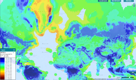
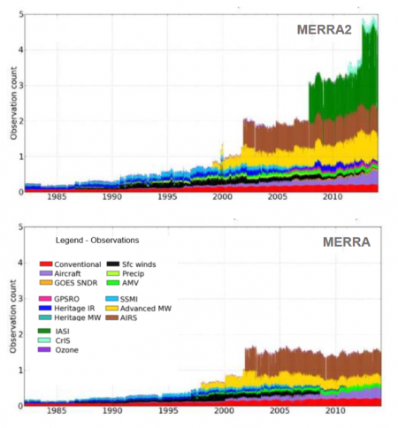
MERRA-2 is the most recent version of the popular MERRA dataset modelled and distributed by the Global Modeling and Assimilation Office of NASA / Goddard Space Flight Center. The original MERRA dataset is discontinued in early 2016. After this point MERRA-2 is the most recent and updated MERRA dataset. MERRA-2 uses a newer version of the modelling system and also incorporates newer data sources and observations (see the lower-figure to the right).
At EMD, we have done a comprehensive evaluation of the performance of the MERRA2 dataset for wind-energy applications. Please consult the paper by Thøgersen et al, "Is MERRA2 Able to Replace MERRA as a Trusted Reference Wind Dataset?". The paper is available from the windPRO knowledgebase, here.
Dataset Overview
- Content:: Renewable energy focused data subset of MERRA2 data.
- Spatial Resolution:
- 0.5 degree latitude
- 0.625 degree longitude
- Temporal Resolution: Hourly values.
- Coverage:
- Coverage is global for land-areas and coastal regions.
- In windPRO, offshore coverage is at a distance of approximately 300 km from any known coastlines.
- Period: 25+ years. The EMD databases will hold data back to 1992.
- Update schedule:
- EMD updates the dataset once a month - with data being available with a 1-2 month delay from real-time due to NASA/MERRA data availability.
Usage Notes and User Notifications
- 2021-12-23: This issue from November 30th (see below) has now been resolved. Updated data from June to October have been made available in our online-data services. We can confirm that the wind fields are also influenced by the issue, see the map of differences in the July 2021 wind speeds here. Thus, if you have downloaded and used MERRA2 data for months June-September 2021 and the data was downloaded before November 30th, then we recommend replacing the erroneous data and re-do any calculations and analysis’. Read our windPRO newsletter from December 23rd - here.
- 2021-11-30: NASA has notified us about an issue with the MERRA2 data from a 4-month period ranging from June 2021 to September 2021. The issue is caused by an error in the MERRA2 pre-processing of ocean buoys observations of near-surface temperatures – resulting in significant near-surface temperature biases in various regions. It is currently not clear to EMD if other parameters than near-surface temperatures are also influenced, and if so, to which degree. As such, MERRA2 data from June-September 2021 has now been removed from the windPRO online-data services. For users who have downloaded these MERRA2 containing the 4 months above, we recommend that you consider taking the following actions with your windPRO project: 1) Remove the MERRA2-data for the months of June 2021 - September 2021. 2) Redo any calculations or reports where you have used these months. We will add a new notification here when corrected MERRA2 data for June 2021 - September 2021 has become available from NASA sources. According to NASA, the corrected data is likely to be released during mid-December 2021. Read the original statement from NASA, here. Read the windPRO newsletter about this issue, here.
- 2020-11-05: NASA has released a revised MERRA-2 dataset covering the month of September 2020. This revised data is released with windPRO on November 6th 2020. It is confirmed that the 50m wind-speeds are affected, see our map that visualizes the difference between the two batches of data - here. We have also a plot that visualizes the time-series differences in 50m wind speed for a single node at location N56.0 E9.4, here. If you have downloaded the September 2020 data in the period from October 24th to November 3rd, we recommend that you: 1) Delete the month of September 2020. 2) Download the most recent data. 3) Re-do your calculations. Read the final newsletter about this issue here
- 2020-11-03: NASA has notified us about an issue with the September 2020 data (released from NASA on October 20th 2020). The MERRA-2 science team at NASA do not recommend using the data - and are currently reprocessing the data. In the windPRO online-data services, September 2020 data has now been removed as of November 3rd. If you have downloaded the MERRA-2 data in the period between October 24th to November 3rd, we recommend that you disable or remove the MERRA2-data for the month of September 2020. The actual nature of the issue is unknown to the windPRO online-data team. We will send out a notification when new data has been released from NASA. Read the original statement from NASA here. Read the windPRO newsletter about this issue, here.
Data Availability
MERRA-2 data is commonly available within windPRO with a time-lag of 1-2 months. This is due to the processing time of the data at NASA and the subset-processing at EMD. When the data have been processed at EMD, then the following parameters are available from within the online-data services within windPRO. Please note that the displacement height is the height at which the log wind profile projects the wind to be zero.
| Parameter | Description | Unit |
|---|---|---|
| time | UTC time stamp | YYYY-MM-DD HH:MM |
| psfc | Surface pressure | Pa |
| msl | Mean Sea Level pressure | Pa |
| wSpeed.50 | Wind speed at 50 m above surface | m/s |
| wDir.50 | Wind direction at 50 m above surface | deg |
| wSpeed.850hpa | Wind speed at 850 hpa | m/s |
| wDir.850hpa | Wind direction at 850hpa | deg |
| temperature.10 | Temperature at 10 m above surface | celcius |
| temperature.50 | Temperature at 50 m above surface | celcius |
| dispHeight | Displacement height | m |
| precIceWater | Total precipitable ice water | g/m^2 |
| precLiqWater | Total precipitable liquid water | g/m^2 |
| precWaterVapor | Total precipitable water vapor | g/m^2 |
| specHumidity.10 | Specific humidity at 10 m | g/kg |
Note on 50m temperature records:
The MERRA2 dataset does not hold temperatures in 50m height, so this is modelled from the 2 m native temperature data - by invoking the global temperature lapse rate from the Standard Atmosphere Model (essentially 0.65 degree C per 100 m, i.e. an adjustment of 0.312 degree C from 2 m to 50 m). The same approach was used for the MERRA Data in windPRO.
External Links and References
- The MERRA-2 project page - HERE
- Bosilovich et al "MERRA-2: Initial Evaluation of the Climate" - HERE
- Thøgersen et al, "Is MERRA2 Able to Replace MERRA as a Trusted Reference Wind Dataset?" - HERE.
Acknowledgement
Credits: The Global Modeling and Assimilation Office (GMAO) for the MERRA-analysis and the GES DISC for the dissemination of MERRA.