NCEP / NCAR Global Reanalysis Data: Difference between revisions
No edit summary |
|||
| Line 19: | Line 19: | ||
== NCEP/NCAR Global Reanalysis Dataset at EMD == | == NCEP/NCAR Global Reanalysis Dataset at EMD == | ||
Currently, two types of NCEP/NCAR modeled wind data are available from the EMD server. Both types of data are distributed through the NCAR_Basic dataset from the EMD server. The raw data are processed by EMD as the original data holds the vector components for the wind speeds only (U and V – winds). We convert the raw data into a format appropriate for use with wind turbine applications, i.e. wind speed and direction instead. | Currently, two types of NCEP/NCAR modeled wind data are available from the EMD server. Both types of data are distributed through the NCAR_Basic dataset from the EMD server. The raw data are processed by EMD as the original data holds the vector components for the wind speeds only (U and V – winds). We convert the raw data into a format appropriate for use with wind turbine applications, i.e. wind speed and direction instead. | ||
<center> | |||
{| class="wikitable" | |||
|+ align="bottom"|Table: Surface Data | |||
!Name | |||
!Description | |||
|- | |||
|Abbreviation | |||
|srf | |||
|- | |||
|External URL | |||
|http://www.cdc.noaa.gov/cdc/data.ncep.reanalysis.surface.html | |||
|- | |||
|Data valid at time | |||
|Instantaneous values at the reference time | |||
|- | |||
|Referred to as | |||
|“Wind" at level "sig995" under main title "Surface" | |||
|- | |||
|Level | |||
|99.5% of surface pressure<br>(approximately 42m a.g.l. for standard atmosphere conditions) | |||
|- | |||
|Grid | |||
|2.5 degree latitude x 2.5 degree longitude global grid (144x73) | |||
|- | |||
|Coverage | |||
|Global | |||
|- | |||
|Columns in data-file | |||
|srf.dir.2 = Wind Direction at sigma level 0.995, i.e. 42 m a.g.l<br>srf.wsp.2 = Wind Speed at sigma level 0.995, i.e. 42 m a.g.l<br>gl.tmp.2 = Temperature at sigma level 0.995, i.e. at 42 m a.g.l | |||
|} | |||
</center> | |||
Revision as of 14:33, 26 May 2013

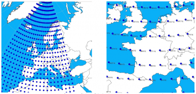
Left = Nodes Covering Western Europe. Right = Nodes Covering France.
Data from the NCEP/NCAR reanalysis project is currently available to users of WindPRO as part of the on-line services from the EMD server. A connection to the internet is thus required. Users may download updated data from the present moment (typically the preceding month) back until 1948.
The sub-set of the NCEP/NCAR Global Reanalysis Data that we hold at EMD is updated on a monthly to bi-monthly update cycle.
Data Description
The NCEP/NCAR model dataset is immense, containing a very wide range of descriptive atmospheric model data. The actual measured climate data sources used in the global reanalysis model are:
- Upperair rawinsonde observations of temperature, horizontal wind, and specific humidity (i.e. weather balloons)
- Operational Television Infrared Observation Satellite (TIROS) Operational Vertical Sounder (TOVS) vertical temperature soundings from NOAA polar orbiters over ocean, with microwave retrievals excluded between 20°N and 20°S due to rain contamination
- TOVS temperature soundings over land only above 100 hPa
- Cloud-tracked winds from geostationary satellites
- Aircraft observations of wind and temperature
- Land surface reports of surface pressure
- Oceanic reports of surface pressure, temperature, horizontal wind, and specific humidity
These data are used as input into a frozen global assimilation system and processed by a spectral model in order to provide the model output of the variables in the grid.
NCEP/NCAR Global Reanalysis Dataset at EMD
Currently, two types of NCEP/NCAR modeled wind data are available from the EMD server. Both types of data are distributed through the NCAR_Basic dataset from the EMD server. The raw data are processed by EMD as the original data holds the vector components for the wind speeds only (U and V – winds). We convert the raw data into a format appropriate for use with wind turbine applications, i.e. wind speed and direction instead.
| Name | Description |
|---|---|
| Abbreviation | srf |
| External URL | http://www.cdc.noaa.gov/cdc/data.ncep.reanalysis.surface.html |
| Data valid at time | Instantaneous values at the reference time |
| Referred to as | “Wind" at level "sig995" under main title "Surface" |
| Level | 99.5% of surface pressure (approximately 42m a.g.l. for standard atmosphere conditions) |
| Grid | 2.5 degree latitude x 2.5 degree longitude global grid (144x73) |
| Coverage | Global |
| Columns in data-file | srf.dir.2 = Wind Direction at sigma level 0.995, i.e. 42 m a.g.l srf.wsp.2 = Wind Speed at sigma level 0.995, i.e. 42 m a.g.l gl.tmp.2 = Temperature at sigma level 0.995, i.e. at 42 m a.g.l |