Category:Maps: Difference between revisions
m (Minor spellings) |
mNo edit summary |
||
| (One intermediate revision by the same user not shown) | |||
| Line 1: | Line 1: | ||
[[Category:Online Data]] | [[Category:Online Data]] | ||
[[File:MapData_Example.png|thumb|right|255px|GeoCover Map in WindPRO]]Several free and commercial sources of relatively high-resolution satellite images are now available on the Internet. These images come in resolutions down to approximately | [[File:MapData_Example.png|thumb|right|255px|GeoCover Map in WindPRO]]Several free (open-source) and commercial sources of relatively high-resolution satellite images are now available on the Internet. These images come in resolutions down to approximately 5-10 meters per pixel for the regional and global goverage maps - thus opening for the possibility to identify details such as large and houses. In WindPRO these photos may be used as background maps and as nice textures for virtual reality presentations (3D animator). | ||
Recently, dedicated maps have become available from services such as Microsoft Bing, Google Maps and OpenStreetMap. Also, | Recently, dedicated maps have become available from services such as Microsoft Bing, Google Maps and OpenStreetMap. Also, more countries like Denmark and Great Britain are releasing their source maps through open-data licenses, making the data available for integration into services like the WindPRO online data. Very many of these new data-services are available through the [[Web_Map_Service|WMS service]] in WindPRO - or as part of the [[Dynamic_maps|zoomable, dynamic maps]]. | ||
Latest revision as of 11:54, 31 July 2019

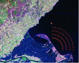
Several free (open-source) and commercial sources of relatively high-resolution satellite images are now available on the Internet. These images come in resolutions down to approximately 5-10 meters per pixel for the regional and global goverage maps - thus opening for the possibility to identify details such as large and houses. In WindPRO these photos may be used as background maps and as nice textures for virtual reality presentations (3D animator).
Recently, dedicated maps have become available from services such as Microsoft Bing, Google Maps and OpenStreetMap. Also, more countries like Denmark and Great Britain are releasing their source maps through open-data licenses, making the data available for integration into services like the WindPRO online data. Very many of these new data-services are available through the WMS service in WindPRO - or as part of the zoomable, dynamic maps.
Pages in category "Maps"
The following 26 pages are in this category, out of 26 total.